

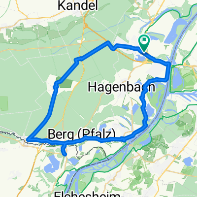
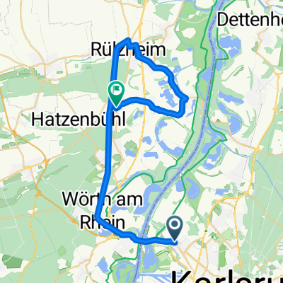
Deutsch-Französische Maifahrt - RTF des RSC Wörth 1980 e.V. - 151 km Strecke
A cycling route starting in Wörth am Rhein, Rhineland-Palatinate, Germany.
Overview
About this route
Deutsch-Französische Maifahrt - 151 km
RTF des RSC Wörth 1980 e.V.
Alle weiteren Hinweise zu dieser Strecke -> hier anklicken
- -:--
- Duration
- 149 km
- Distance
- 636 m
- Ascent
- 635 m
- Descent
- ---
- Avg. speed
- ---
- Max. altitude

Route quality
Waytypes & surfaces along the route
Waytypes
Road
43.2 km
(29 %)
Track
17.9 km
(12 %)
Surfaces
Paved
122.2 km
(82 %)
Unpaved
8.9 km
(6 %)
Asphalt
117.7 km
(79 %)
Gravel
6 km
(4 %)
Route highlights
Points of interest along the route
Drinking water after 68.5 km
Kontrolle
Drinking water after 101.7 km
Kontrolle
Drinking water after 131.3 km
Kontrolle wird zweimal angefahren
Continue with Bikemap
Use, edit, or download this cycling route
You would like to ride Deutsch-Französische Maifahrt - RTF des RSC Wörth 1980 e.V. - 151 km Strecke or customize it for your own trip? Here is what you can do with this Bikemap route:
Free features
- Save this route as favorite or in collections
- Copy & plan your own version of this route
- Split it into stages to create a multi-day tour
- Sync your route with Garmin or Wahoo
Premium features
Free trial for 3 days, or one-time payment. More about Bikemap Premium.
- Navigate this route on iOS & Android
- Export a GPX / KML file of this route
- Create your custom printout (try it for free)
- Download this route for offline navigation
Discover more Premium features.
Get Bikemap PremiumFrom our community
Other popular routes starting in Wörth am Rhein
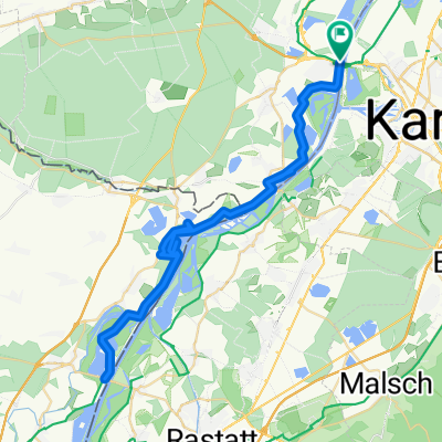
 44_Wörth – Lauterbourg (F) – Wörth
- Distance
- 37.6 km
- Ascent
- 71 m
- Descent
- 71 m
- Location
- Wörth am Rhein, Rhineland-Palatinate, Germany
 Maximiliansau
- Distance
- 58.1 km
- Ascent
- 186 m
- Descent
- 240 m
- Location
- Wörth am Rhein, Rhineland-Palatinate, Germany
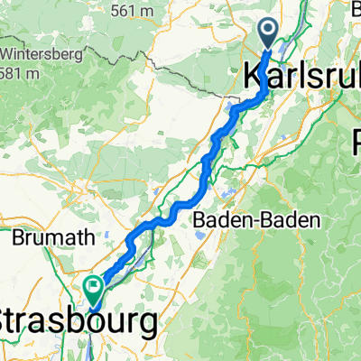 Wörth am Rhein - Kehl
- Distance
- 77.1 km
- Ascent
- 206 m
- Descent
- 168 m
- Location
- Wörth am Rhein, Rhineland-Palatinate, Germany
 Wörth am Rhein - Worms
- Distance
- 113.2 km
- Ascent
- 0 m
- Descent
- 15 m
- Location
- Wörth am Rhein, Rhineland-Palatinate, Germany
 Elsassrunde
- Distance
- 60.2 km
- Ascent
- 176 m
- Descent
- 187 m
- Location
- Wörth am Rhein, Rhineland-Palatinate, Germany
 Eisenbahnstraße, Wörth am Rhein nach Rue Jacques Twinger, Drusenheim
- Distance
- 54.2 km
- Ascent
- 143 m
- Descent
- 126 m
- Location
- Wörth am Rhein, Rhineland-Palatinate, Germany
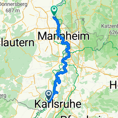
 Knielingen, Karlsruhe nach Flachsmarkt, Rheinzabern
- Distance
- 32.4 km
- Ascent
- 87 m
- Descent
- 88 m
- Location
- Wörth am Rhein, Rhineland-Palatinate, Germany
 CYCLING THE RHINE: Route 17A
- Distance
- 82 km
- Ascent
- 75 m
- Descent
- 41 m
- Location
- Wörth am Rhein, Rhineland-Palatinate, Germany
Open it in the app