

Wettersteinalm über Bannholzweg
A cycling route starting in Mittenwald, Bavaria, Germany.
Overview
About this route
Anforderungen: Mittelschwere MTB-Tour. Durchschnittliche Fitness und fortgeschrittene Fahrtechnik erforderlich.
Tourcharakter: Gut befestigte Wirtschaftswege, mit steilen Anstiegen und Abfahrten.
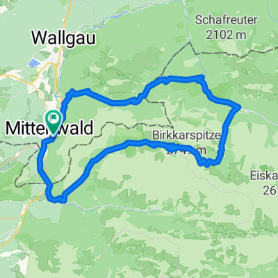
Streckenbeschreibung: Von der Hotelausfahrt biegen wir nach rechts auf die Mautstraße ab, verlassen diese vor dem Wald wieder nach rechts und folgen Weg-Nr. 843 nach Elmau. Dort halten wir uns an den Weg-Nr. 820 nach Mittenwald. Nach ca. 2,5 Km wählen wir an der dortigen Wegegabelung Weg-Nr. 870 zur Wettersteinalm/Schachen. Wir bleiben bis zur Einmündung in Weg-Nr. 841 auf der Fahrstraße und biegen dort links zur Wettersteinalm ab.
Der Rückweg erfolgt über Weg-Nr. 841 direkt nach Elmau. Unterhalb des Schlosses vorbei, auf Weg-Nr. 843 zurück zum Hotel.
- -:--
- Duration
- 21.6 km
- Distance
- 703 m
- Ascent
- 710 m
- Descent
- ---
- Avg. speed
- ---
- Max. altitude

Route quality
Waytypes & surfaces along the route
Waytypes
Track
18.8 km
(87 %)
Quiet road
1.5 km
(7 %)
Surfaces
Paved
1.7 km
(8 %)
Unpaved
18.8 km
(87 %)
Gravel
18.8 km
(87 %)
Asphalt
1.7 km
(8 %)
Undefined
1.1 km
(5 %)
Continue with Bikemap
Use, edit, or download this cycling route
You would like to ride Wettersteinalm über Bannholzweg or customize it for your own trip? Here is what you can do with this Bikemap route:
Free features
- Save this route as favorite or in collections
- Copy & plan your own version of this route
- Sync your route with Garmin or Wahoo
Premium features
Free trial for 3 days, or one-time payment. More about Bikemap Premium.
- Navigate this route on iOS & Android
- Export a GPX / KML file of this route
- Create your custom printout (try it for free)
- Download this route for offline navigation
Discover more Premium features.
Get Bikemap PremiumFrom our community
Other popular routes starting in Mittenwald
 Karwendeltour
- Distance
- 78.4 km
- Ascent
- 1,998 m
- Descent
- 1,998 m
- Location
- Mittenwald, Bavaria, Germany
 Mittenwald -St.Moritz(CH)
- Distance
- 204.3 km
- Ascent
- 2,276 m
- Descent
- 1,364 m
- Location
- Mittenwald, Bavaria, Germany
 Karwendelrunde
- Distance
- 65 km
- Ascent
- 1,582 m
- Descent
- 1,572 m
- Location
- Mittenwald, Bavaria, Germany
 Mittenwald-ElmauerAlm-HoherKranzberg-Arnspitzrunde
- Distance
- 70.3 km
- Ascent
- 1,142 m
- Descent
- 1,142 m
- Location
- Mittenwald, Bavaria, Germany
 Mittenwald - Riva
- Distance
- 389.2 km
- Ascent
- 7,671 m
- Descent
- 8,511 m
- Location
- Mittenwald, Bavaria, Germany
 Letzte Etappe Ulm-Gardasee-Ulm
- Distance
- 214.9 km
- Ascent
- 1,305 m
- Descent
- 1,666 m
- Location
- Mittenwald, Bavaria, Germany
 Soiern-Runde
- Distance
- 48.6 km
- Ascent
- 945 m
- Descent
- 945 m
- Location
- Mittenwald, Bavaria, Germany
 Karwendelrunde light - Mittenwald - Scharnitz - Karwendelhaus - Hinterriss - Vorderriss - Wallgau
- Distance
- 75.5 km
- Ascent
- 1,530 m
- Descent
- 1,530 m
- Location
- Mittenwald, Bavaria, Germany
Open it in the app