

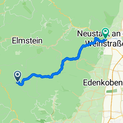
Taubensuhl-Rietburg-LD
A cycling route starting in Eußerthal, Rhineland-Palatinate, Germany.
Overview
About this route
- -:--
- Duration
- 34.9 km
- Distance
- 408 m
- Ascent
- 769 m
- Descent
- ---
- Avg. speed
- ---
- Max. altitude
Route quality
Waytypes & surfaces along the route
Waytypes
Track
25.8 km
(74 %)
Path
3.8 km
(11 %)
Surfaces
Paved
7.7 km
(22 %)
Unpaved
22.3 km
(64 %)
Gravel
15 km
(43 %)
Ground
5.6 km
(16 %)
Continue with Bikemap
Use, edit, or download this cycling route
You would like to ride Taubensuhl-Rietburg-LD or customize it for your own trip? Here is what you can do with this Bikemap route:
Free features
- Save this route as favorite or in collections
- Copy & plan your own version of this route
- Sync your route with Garmin or Wahoo
Premium features
Free trial for 3 days, or one-time payment. More about Bikemap Premium.
- Navigate this route on iOS & Android
- Export a GPX / KML file of this route
- Create your custom printout (try it for free)
- Download this route for offline navigation
Discover more Premium features.
Get Bikemap PremiumFrom our community
Other popular routes starting in Eußerthal
 Taubensuhl
- Distance
- 23 km
- Ascent
- 299 m
- Descent
- 681 m
- Location
- Eußerthal, Rhineland-Palatinate, Germany
 Rheinebenetour Eußerthal Wörth zurück über Hörth und Bellheim
- Distance
- 98 km
- Ascent
- 175 m
- Descent
- 168 m
- Location
- Eußerthal, Rhineland-Palatinate, Germany
 10-MRZ-12
- Distance
- 13.2 km
- Ascent
- 567 m
- Descent
- 569 m
- Location
- Eußerthal, Rhineland-Palatinate, Germany
 17-SEP-11
- Distance
- 17.6 km
- Ascent
- 626 m
- Descent
- 626 m
- Location
- Eußerthal, Rhineland-Palatinate, Germany
 Taubensuhl-NF-FBTHütte
- Distance
- 24.4 km
- Ascent
- 181 m
- Descent
- 391 m
- Location
- Eußerthal, Rhineland-Palatinate, Germany
 Taubensuhl Bergzeitfahren
- Distance
- 6.6 km
- Ascent
- 439 m
- Descent
- 130 m
- Location
- Eußerthal, Rhineland-Palatinate, Germany
 1Taubensuhl-JKreuz-Finsterbrunnertal-Z53
- Distance
- 25 km
- Ascent
- 181 m
- Descent
- 379 m
- Location
- Eußerthal, Rhineland-Palatinate, Germany
 Heldenstein, Taubensuhl, Helmbachweyher...Heldenstein
- Distance
- 27.2 km
- Ascent
- 452 m
- Descent
- 452 m
- Location
- Eußerthal, Rhineland-Palatinate, Germany
Open it in the app