
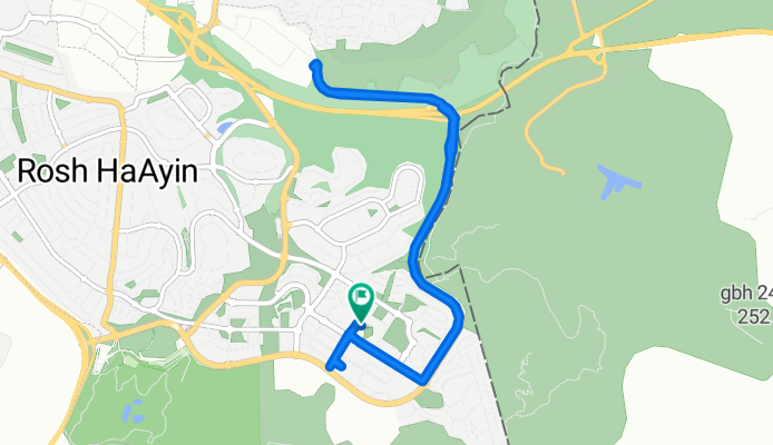
Shaike Ofir Street 12, Rosh Haayin to Shaike Ofir Street 13, Rosh Haayin
A cycling route starting in Dayr Ballūţ, West Bank, Palestine.
Overview
About this route
- 1 h 33 min
- Duration
- 11.5 km
- Distance
- 214 m
- Ascent
- 187 m
- Descent
- 7.4 km/h
- Avg. speed
- ---
- Max. altitude

Route photos

Continue with Bikemap
Use, edit, or download this cycling route
You would like to ride Shaike Ofir Street 12, Rosh Haayin to Shaike Ofir Street 13, Rosh Haayin or customize it for your own trip? Here is what you can do with this Bikemap route:
Free features
- Save this route as favorite or in collections
- Copy & plan your own version of this route
- Sync your route with Garmin or Wahoo
Premium features
Free trial for 3 days, or one-time payment. More about Bikemap Premium.
- Navigate this route on iOS & Android
- Export a GPX / KML file of this route
- Create your custom printout (try it for free)
- Download this route for offline navigation
Discover more Premium features.
Get Bikemap PremiumFrom our community
Other popular routes starting in Dayr Ballūţ
 hills
hills- Distance
- 10.4 km
- Ascent
- 147 m
- Descent
- 152 m
- Location
- Dayr Ballūţ, West Bank, Palestine
 ראש העין - ירקון - 1
- Distance
- 10 km
- Ascent
- 31 m
- Descent
- 131 m
- Location
- Dayr Ballūţ, West Bank, Palestine
 ראש העין למצפה מודיעין
- Distance
- 20.8 km
- Ascent
- 356 m
- Descent
- 311 m
- Location
- Dayr Ballūţ, West Bank, Palestine
 ראש העין מני ניסיון
- Distance
- 23 km
- Ascent
- 242 m
- Descent
- 242 m
- Location
- Dayr Ballūţ, West Bank, Palestine
 Shaike Ofir Street 12, Rosh Haayin to Shaike Ofir Street 13, Rosh Haayin
- Distance
- 11.5 km
- Ascent
- 214 m
- Descent
- 187 m
- Location
- Dayr Ballūţ, West Bank, Palestine
 ראש העין - בן שמן
- Distance
- 49.9 km
- Ascent
- 398 m
- Descent
- 395 m
- Location
- Dayr Ballūţ, West Bank, Palestine
 Slow ride in
- Distance
- 7.3 km
- Ascent
- 139 m
- Descent
- 138 m
- Location
- Dayr Ballūţ, West Bank, Palestine
 ראש העין - ירקון - ניסיון - 2
- Distance
- 10.5 km
- Ascent
- 51 m
- Descent
- 154 m
- Location
- Dayr Ballūţ, West Bank, Palestine
Open it in the app