

2015_Teisendorf_Freilassing
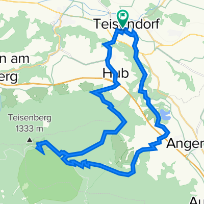
A cycling route starting in Teisendorf, Bavaria, Germany.
Overview
About this route
Vorzeitiger Abbruch wegen Regengüssen
- -:--
- Duration
- 44.1 km
- Distance
- 100 m
- Ascent
- 181 m
- Descent
- ---
- Avg. speed
- ---
- Max. altitude

Route quality
Waytypes & surfaces along the route
Waytypes
Quiet road
17.2 km
(39 %)
Path
12.8 km
(29 %)
Surfaces
Paved
33.1 km
(75 %)
Unpaved
6.2 km
(14 %)
Asphalt
33.1 km
(75 %)
Gravel
5.7 km
(13 %)
Continue with Bikemap
Use, edit, or download this cycling route
You would like to ride 2015_Teisendorf_Freilassing or customize it for your own trip? Here is what you can do with this Bikemap route:
Free features
- Save this route as favorite or in collections
- Copy & plan your own version of this route
- Sync your route with Garmin or Wahoo
Premium features
Free trial for 3 days, or one-time payment. More about Bikemap Premium.
- Navigate this route on iOS & Android
- Export a GPX / KML file of this route
- Create your custom printout (try it for free)
- Download this route for offline navigation
Discover more Premium features.
Get Bikemap PremiumFrom our community
Other popular routes starting in Teisendorf
 Stoißeralm
- Distance
- 26.4 km
- Ascent
- 795 m
- Descent
- 795 m
- Location
- Teisendorf, Bavaria, Germany
 Alpenvorland_Tour29_Waginger See
- Distance
- 35.8 km
- Ascent
- 353 m
- Descent
- 353 m
- Location
- Teisendorf, Bavaria, Germany
 Abtsdorfer See
- Distance
- 44.2 km
- Ascent
- 324 m
- Descent
- 327 m
- Location
- Teisendorf, Bavaria, Germany
 Tsdf Traunstein Teisenberg
- Distance
- 34.7 km
- Ascent
- 363 m
- Descent
- 363 m
- Location
- Teisendorf, Bavaria, Germany
 test
test- Distance
- 20.1 km
- Ascent
- 153 m
- Descent
- 194 m
- Location
- Teisendorf, Bavaria, Germany
 Stoißeralm
- Distance
- 26.3 km
- Ascent
- 1,098 m
- Descent
- 993 m
- Location
- Teisendorf, Bavaria, Germany
 Ibm-Runde
- Distance
- 109.6 km
- Ascent
- 1,193 m
- Descent
- 1,227 m
- Location
- Teisendorf, Bavaria, Germany
 2012 Teisendorf-Schönau/Königssee
- Distance
- 48.8 km
- Ascent
- 446 m
- Descent
- 335 m
- Location
- Teisendorf, Bavaria, Germany
Open it in the app