
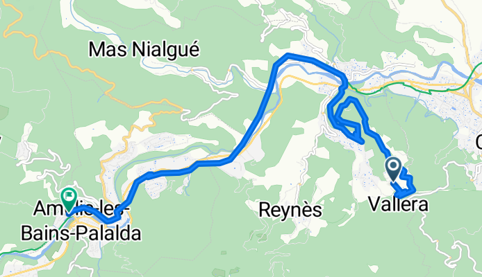
De Coll de Bousseils 84-396, Reynes à Rue de la Riviera 40, Amélie-les-Bains-Palalda
A cycling route starting in Reynès, Occitanie, France.
Overview
About this route
- 1 h 22 min
- Duration
- 12.4 km
- Distance
- 179 m
- Ascent
- 179 m
- Descent
- 9.1 km/h
- Avg. speed
- ---
- Max. altitude

Route photos

Route quality
Waytypes & surfaces along the route
Waytypes
Quiet road
6.8 km
(55 %)
Path
3.2 km
(26 %)
Surfaces
Paved
7.7 km
(62 %)
Unpaved
2.8 km
(23 %)
Asphalt
4.6 km
(37 %)
Concrete
3.1 km
(25 %)
Continue with Bikemap
Use, edit, or download this cycling route
You would like to ride De Coll de Bousseils 84-396, Reynes à Rue de la Riviera 40, Amélie-les-Bains-Palalda or customize it for your own trip? Here is what you can do with this Bikemap route:
Free features
- Save this route as favorite or in collections
- Copy & plan your own version of this route
- Sync your route with Garmin or Wahoo
Premium features
Free trial for 3 days, or one-time payment. More about Bikemap Premium.
- Navigate this route on iOS & Android
- Export a GPX / KML file of this route
- Create your custom printout (try it for free)
- Download this route for offline navigation
Discover more Premium features.
Get Bikemap PremiumFrom our community
Other popular routes starting in Reynès

 De Camp Grand 940, Reynes à Rue de la Riviera 40, Amélie-les-Bains-Palalda
- Distance
- 8.3 km
- Ascent
- 265 m
- Descent
- 234 m
- Location
- Reynès, Occitanie, France
 tour des alberes
- Distance
- 143.3 km
- Ascent
- 805 m
- Descent
- 859 m
- Location
- Reynès, Occitanie, France
 De La Roure, Taillet à La Roure 59, Taillet
- Distance
- 1.3 km
- Ascent
- 65 m
- Descent
- 4 m
- Location
- Reynès, Occitanie, France
 De Coll de Bousseils 84-396, Reynes à Rue de la Riviera 40, Amélie-les-Bains-Palalda
- Distance
- 12.4 km
- Ascent
- 179 m
- Descent
- 179 m
- Location
- Reynès, Occitanie, France
 PR DIA 4
- Distance
- 104.7 km
- Ascent
- 1,574 m
- Descent
- 2,313 m
- Location
- Reynès, Occitanie, France
 Itinéraire modéré en
- Distance
- 11.2 km
- Ascent
- 258 m
- Descent
- 222 m
- Location
- Reynès, Occitanie, France
 De 68–72 Chemin de Reynes, Oms à 6ter Place de la République, Céret
- Distance
- 22.5 km
- Ascent
- 251 m
- Descent
- 481 m
- Location
- Reynès, Occitanie, France
Open it in the app