

MTB-Tour Quer durch Lava und Wein
A cycling route starting in Tinajo, Canary Islands, Spain.
Overview
About this route
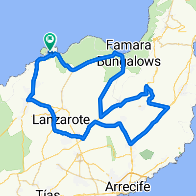
Start at the parking lot on LZ-56 just before Hoya de la Pena, crossing lava rock and passing a walkable lava cave (km 4.5) to El Grifo, past the foot of Montana Blanca, above Tias to La Asomada with a stunning view of the coast and sea, a steep climb to Tinasoria at 503 m with breathtaking panoramic views, descent to La Geria, along LZ 30 through the wine-growing area, along the foot of Montana Negra, circling the Caldera Colorada, passing the 'stone bomb', an approximately 50-ton lava plug, and back to the starting point.
- -:--
- Duration
- 42 km
- Distance
- 510 m
- Ascent
- 510 m
- Descent
- ---
- Avg. speed
- ---
- Max. altitude
Route highlights
Points of interest along the route
Point of interest after 13.4 km
Point of interest after 13.4 km
Continue with Bikemap
Use, edit, or download this cycling route
You would like to ride MTB-Tour Quer durch Lava und Wein or customize it for your own trip? Here is what you can do with this Bikemap route:
Free features
- Save this route as favorite or in collections
- Copy & plan your own version of this route
- Sync your route with Garmin or Wahoo
Premium features
Free trial for 3 days, or one-time payment. More about Bikemap Premium.
- Navigate this route on iOS & Android
- Export a GPX / KML file of this route
- Create your custom printout (try it for free)
- Download this route for offline navigation
Discover more Premium features.
Get Bikemap PremiumFrom our community
Other popular routes starting in Tinajo
 Lanzarote Giorno 2
- Distance
- 114.6 km
- Ascent
- 1,445 m
- Descent
- 1,449 m
- Location
- Tinajo, Canary Islands, Spain
 Nationalpark Timanfaya (Feuerberge)
- Distance
- 56 km
- Ascent
- 594 m
- Descent
- 597 m
- Location
- Tinajo, Canary Islands, Spain
 Feuer lang 59
- Distance
- 59.7 km
- Ascent
- 879 m
- Descent
- 880 m
- Location
- Tinajo, Canary Islands, Spain
 Conil Trip - Distance 50km
- Distance
- 52.2 km
- Ascent
- 415 m
- Descent
- 415 m
- Location
- Tinajo, Canary Islands, Spain
 65km Inseltour Vegueta
- Distance
- 65.3 km
- Ascent
- 825 m
- Descent
- 825 m
- Location
- Tinajo, Canary Islands, Spain
 Lanzarote Playa Blanca
- Distance
- 88.3 km
- Ascent
- 883 m
- Descent
- 890 m
- Location
- Tinajo, Canary Islands, Spain
 Tabayesco 85km
- Distance
- 85.2 km
- Ascent
- 1,381 m
- Descent
- 1,383 m
- Location
- Tinajo, Canary Islands, Spain
 La Santa El Mojon Tahiche
- Distance
- 66.6 km
- Ascent
- 679 m
- Descent
- 680 m
- Location
- Tinajo, Canary Islands, Spain
Open it in the app