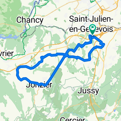
Route de la Capitaine, Saint-Julien-en-Genevois to Chemin du Pont Lambin 46, Saint-Julien-en-Genevois
A cycling route starting in Saint-Julien-en-Genevois, Auvergne-Rh么ne-Alpes, France.
Overview
About this route
- 1 h 4 min
- Duration
- 23.2 km
- Distance
- 315 m
- Ascent
- 331 m
- Descent
- 21.6 km/h
- Avg. speed
- ---
- Avg. speed
Route quality
Waytypes & surfaces along the route
Waytypes
Quiet road
9.9 km
(43 %)
Busy road
6.8 km
(29 %)
Surfaces
Paved
2.9 km
(12 %)
Asphalt
2.9 km
(12 %)
Undefined
20.4 km
(88 %)
Continue with Bikemap
Use, edit, or download this cycling route
You would like to ride Route de la Capitaine, Saint-Julien-en-Genevois to Chemin du Pont Lambin 46, Saint-Julien-en-Genevois or customize it for your own trip? Here is what you can do with this Bikemap route:
Free features
- Save this route as favorite or in collections
- Copy & plan your own version of this route
- Sync your route with Garmin or Wahoo
Premium features
Free trial for 3 days, or one-time payment. More about Bikemap Premium.
- Navigate this route on iOS & Android
- Export a GPX / KML file of this route
- Create your custom printout (try it for free)
- Download this route for offline navigation
Discover more Premium features.
Get Bikemap PremiumFrom our community
Other popular routes starting in Saint-Julien-en-Genevois
- Local 40km
- Distance
- 40.3 km
- Ascent
- 569 m
- Descent
- 568 m
- Location
- Saint-Julien-en-Genevois, Auvergne-Rh么ne-Alpes, France
- Charly/Chenex
- Distance
- 30.1 km
- Ascent
- 405 m
- Descent
- 408 m
- Location
- Saint-Julien-en-Genevois, Auvergne-Rh么ne-Alpes, France
- Slow ride in Dingy-en-Vuache
- Distance
- 36.6 km
- Ascent
- 449 m
- Descent
- 449 m
- Location
- Saint-Julien-en-Genevois, Auvergne-Rh么ne-Alpes, France
- 1 - Saint-Julien to Seyssel - Backup 2
- Distance
- 83.3 km
- Ascent
- 1,928 m
- Descent
- 2,131 m
- Location
- Saint-Julien-en-Genevois, Auvergne-Rh么ne-Alpes, France
- 1 - Saint-Julien to Seyssel - Backup 1
- Distance
- 66.9 km
- Ascent
- 1,332 m
- Descent
- 1,535 m
- Location
- Saint-Julien-en-Genevois, Auvergne-Rh么ne-Alpes, France
- 1 - Saint-Julien to Seyssel - Proposed Route
- Distance
- 96.6 km
- Ascent
- 1,552 m
- Descent
- 1,755 m
- Location
- Saint-Julien-en-Genevois, Auvergne-Rh么ne-Alpes, France
- 1 - Saint-Julien to Seyssel - Backup 3
- Distance
- 55.9 km
- Ascent
- 759 m
- Descent
- 967 m
- Location
- Saint-Julien-en-Genevois, Auvergne-Rh么ne-Alpes, France
- Local 50km
- Distance
- 54.4 km
- Ascent
- 770 m
- Descent
- 770 m
- Location
- Saint-Julien-en-Genevois, Auvergne-Rh么ne-Alpes, France
Open it in the app