

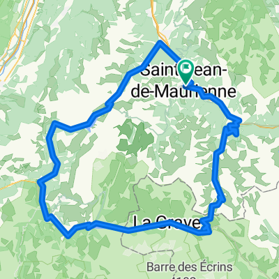
Lacets de Montvernier & Colle del Glandon
A cycling route starting in Saint-Jean-de-Maurienne, Auvergne-Rhône-Alpes, France.
Overview
About this route
- -:--
- Duration
- 55.6 km
- Distance
- 2,474 m
- Ascent
- 1,118 m
- Descent
- ---
- Avg. speed
- ---
- Max. altitude

Route quality
Waytypes & surfaces along the route
Waytypes
Road
23.3 km
(42 %)
Quiet road
8.9 km
(16 %)
Surfaces
Paved
32.2 km
(58 %)
Unpaved
0.6 km
(1 %)
Asphalt
32.2 km
(58 %)
Ground
0.6 km
(1 %)
Undefined
22.8 km
(41 %)
Route highlights
Points of interest along the route
Point of interest after 55.6 km
Continue with Bikemap
Use, edit, or download this cycling route
You would like to ride Lacets de Montvernier & Colle del Glandon or customize it for your own trip? Here is what you can do with this Bikemap route:
Free features
- Save this route as favorite or in collections
- Copy & plan your own version of this route
- Sync your route with Garmin or Wahoo
Premium features
Free trial for 3 days, or one-time payment. More about Bikemap Premium.
- Navigate this route on iOS & Android
- Export a GPX / KML file of this route
- Create your custom printout (try it for free)
- Download this route for offline navigation
Discover more Premium features.
Get Bikemap PremiumFrom our community
Other popular routes starting in Saint-Jean-de-Maurienne
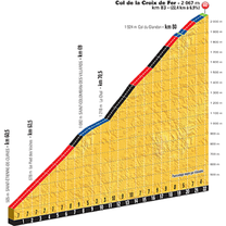
 Col de la Croix de Fer- Col du Glandon
- Distance
- 62.3 km
- Ascent
- 1,665 m
- Descent
- 1,665 m
- Location
- Saint-Jean-de-Maurienne, Auvergne-Rhône-Alpes, France
 montée oullaz par jarrier 002
- Distance
- 12.8 km
- Ascent
- 1,016 m
- Descent
- 30 m
- Location
- Saint-Jean-de-Maurienne, Auvergne-Rhône-Alpes, France
 Maurienne - J3 Bis
- Distance
- 165.7 km
- Ascent
- 3,339 m
- Descent
- 3,340 m
- Location
- Saint-Jean-de-Maurienne, Auvergne-Rhône-Alpes, France
 Etape reine CFJ Tour 2021
- Distance
- 71.7 km
- Ascent
- 1,981 m
- Descent
- 1,960 m
- Location
- Saint-Jean-de-Maurienne, Auvergne-Rhône-Alpes, France
 la montée à LA TOUSSUIRE
- Distance
- 33.9 km
- Ascent
- 1,172 m
- Descent
- 1,173 m
- Location
- Saint-Jean-de-Maurienne, Auvergne-Rhône-Alpes, France
 Maurienne - J4
- Distance
- 76.9 km
- Ascent
- 2,005 m
- Descent
- 2,005 m
- Location
- Saint-Jean-de-Maurienne, Auvergne-Rhône-Alpes, France
 020 - 2014
- Distance
- 71.8 km
- Ascent
- 1,404 m
- Descent
- 178 m
- Location
- Saint-Jean-de-Maurienne, Auvergne-Rhône-Alpes, France
 Maurienne - J3
- Distance
- 164.2 km
- Ascent
- 3,430 m
- Descent
- 3,429 m
- Location
- Saint-Jean-de-Maurienne, Auvergne-Rhône-Alpes, France
Open it in the app