

Canal du Nord (Fietsallee)
A cycling route starting in Nettetal, North Rhine-Westphalia, Germany.
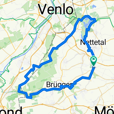
Overview
About this route
Canal du Nord (Fietsallee) - Wir Entdecken neue und alte Spuren des unvollendeten Nordkanals. Das blaue Band der Fietsallee und das orange-weiße Routenlogo führt uns auf einer attraktiven Radroute. - Die Radwanderung ist ein Teilstück der Nordkanals und führt über Nettetal, Venloer-Heide, Alter Nordkanal, Grefrath entlang, auf die Spuren rund um Napoleons Projekt. Zum Größte teil radelt man immer am Fluss entlang vorbei an die Fietsallee bis Neuss.
Hofbräu Märchenwald Biergarten Im Eschert 41 47877 Willich 02154 884180 Ab 11:00 Uhr- -:--
- Duration
- 59.4 km
- Distance
- 36 m
- Ascent
- 41 m
- Descent
- ---
- Avg. speed
- ---
- Max. altitude

Route quality
Waytypes & surfaces along the route
Waytypes
Path
27.1 km
(46 %)
Quiet road
19.6 km
(33 %)
Surfaces
Paved
42 km
(71 %)
Unpaved
12.2 km
(21 %)
Asphalt
37.7 km
(63 %)
Gravel
8.2 km
(14 %)
Route highlights
Points of interest along the route
\"")
Photo after 5.6 km
Heerstraße in Venloer Heide in Höhe Birkenhof
\"")
Photo after 12.9 km
Wegkreuz, Alter Nordkanal
\"")
Photo after 17.6 km
Lobberich
\"")
Photo after 23.2 km
Süchteln, Nordkanalmarkierung
\"")
Point of interest after 26.3 km
Nordkanal in Viersen
\"")
Photo after 35.9 km
Nordkanal
\"")
Point of interest after 37.3 km
Hofbräu Märchenwald Im Eschert 1, 47877 Willich 02154 884180
\"")
Photo after 49.5 km
Rosskastanienallee
\"")
Point of interest after 53.1 km
Noordkanaal, Epanchoir Neuss
\"")
Point of interest after 55.4 km
Nord Kanal Ende
Continue with Bikemap
Use, edit, or download this cycling route
You would like to ride Canal du Nord (Fietsallee) or customize it for your own trip? Here is what you can do with this Bikemap route:
Free features
- Save this route as favorite or in collections
- Copy & plan your own version of this route
- Sync your route with Garmin or Wahoo
Premium features
Free trial for 3 days, or one-time payment. More about Bikemap Premium.
- Navigate this route on iOS & Android
- Export a GPX / KML file of this route
- Create your custom printout (try it for free)
- Download this route for offline navigation
Discover more Premium features.
Get Bikemap PremiumFrom our community
Other popular routes starting in Nettetal
 Heide-Seen Tour (Nettetal)
- Distance
- 59.3 km
- Ascent
- 106 m
- Descent
- 106 m
- Location
- Nettetal, North Rhine-Westphalia, Germany
 GL`s Seen-MTB-Strecke
- Distance
- 33.1 km
- Ascent
- 124 m
- Descent
- 124 m
- Location
- Nettetal, North Rhine-Westphalia, Germany
 Deel 02 Ldam - Wenen: Route van Venlo naar Mamedy 20150406
- Distance
- 163.2 km
- Ascent
- 119 m
- Descent
- 104 m
- Location
- Nettetal, North Rhine-Westphalia, Germany
 Lobberich,Herongen,VenloerHeide,Krickenbeck,Lobberich
- Distance
- 26 km
- Ascent
- 55 m
- Descent
- 56 m
- Location
- Nettetal, North Rhine-Westphalia, Germany
 Nettetalrunde
- Distance
- 30.8 km
- Ascent
- 101 m
- Descent
- 104 m
- Location
- Nettetal, North Rhine-Westphalia, Germany
 Schaag - Hariksee - Heidweiher - Schaag
- Distance
- 20.7 km
- Ascent
- 82 m
- Descent
- 83 m
- Location
- Nettetal, North Rhine-Westphalia, Germany
 Schwalm-Nette
- Distance
- 46.3 km
- Ascent
- 57 m
- Descent
- 58 m
- Location
- Nettetal, North Rhine-Westphalia, Germany
 Nette Route
- Distance
- 28.8 km
- Ascent
- 57 m
- Descent
- 57 m
- Location
- Nettetal, North Rhine-Westphalia, Germany
Open it in the app