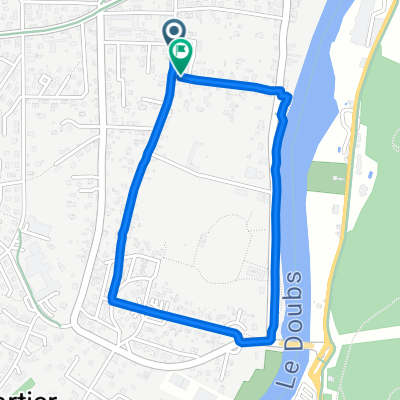
Valentigney - Gunsbach
A cycling route starting in Valentigney, Bourgogne-Franche-Comté, France.
Overview
About this route
Relatively easy, this route can be done in one day, even with bags.
An English and French description follows:
Â
English: You can follow "La coulée verte" from Exincourt until Dannemarie eventhough, here on the map, it follows a road next to the "Canal du Rhône au Rhin".
The road there is really nice, peaceful (only cyclist and pedestrians are allowed)
From Dannemarie until Cernay, the road is gently rolling. After Burnhaupt-le-Haut, follow the road "Route de Schweighouse", you cannot take the D83!
From Cernay until Wintzenheim, you follow the "Route des vins d'Alsace", which cross many beautiful villages, all worth a stop.
The road just after Wintzenheim has heavy traffic, try to quit the D417 as soon as you can.
Français: Il est possible de suivre la coulée verte d'exincourt à Dannemarie, même si sur cette carte la route indiquée est légèrement à côtée. Il suffit de suivre le canal du Rhône au Rhin.
Cette route est superbe et tranquille (seulement pour cycliste et piéton)
De Dannemarie à Cernay, la route est un moins plate, mais encore jolie. Attention en s'approchant de la nationale, le traffic augmente. Après Burnhaupt-le-Haut, prenez la route de Schweighouse, la D83 est interdite au cycliste.
Ensuite de Cernay à Wintzenheim, il suffit de suivre presque tout le temps la route des vins d'Alsace. Les villages traversés sont magnifiques, pensez à y faire quelques arrêts.
La D417 après Wintzenheim a un trafic soutenu, prennez la première opportunité qui se présente pour quitter cette route.
- -:--
- Duration
- 126.2 km
- Distance
- 466 m
- Ascent
- 548 m
- Descent
- ---
- Avg. speed
- 371 m
- Avg. speed
Route quality
Waytypes & surfaces along the route
Waytypes
Road
41.8 km
(33 %)
Busy road
27.6 km
(22 %)
Surfaces
Paved
59.9 km
(47 %)
Unpaved
3.1 km
(2 %)
Asphalt
56.5 km
(45 %)
Paved (undefined)
3.3 km
(3 %)
Continue with Bikemap
Use, edit, or download this cycling route
You would like to ride Valentigney - Gunsbach or customize it for your own trip? Here is what you can do with this Bikemap route:
Free features
- Save this route as favorite or in collections
- Copy & plan your own version of this route
- Sync your route with Garmin or Wahoo
Premium features
Free trial for 3 days, or one-time payment. More about Bikemap Premium.
- Navigate this route on iOS & Android
- Export a GPX / KML file of this route
- Create your custom printout (try it for free)
- Download this route for offline navigation
Discover more Premium features.
Get Bikemap PremiumFrom our community
Other popular routes starting in Valentigney
- essaye
- Distance
- 10.2 km
- Ascent
- 23 m
- Descent
- 27 m
- Location
- Valentigney, Bourgogne-Franche-Comté, France
- JuraExtrem 12.8.-20.8.2023
- Distance
- 982.4 km
- Ascent
- 24,123 m
- Descent
- 24,144 m
- Location
- Valentigney, Bourgogne-Franche-Comté, France
- sortie préparation sortie tour du Léman 2019
- Distance
- 168.8 km
- Ascent
- 1,490 m
- Descent
- 1,460 m
- Location
- Valentigney, Bourgogne-Franche-Comté, France
- 57 Rue Étienne Oehmichen, Valentigney à Place du 8 Mai, Mandeure
- Distance
- 4.3 km
- Ascent
- 23 m
- Descent
- 16 m
- Location
- Valentigney, Bourgogne-Franche-Comté, France
- 85 Rue de Sous-Roches, Valentigney Ă 85 Rue de Sous-Roches, Valentigney
- Distance
- 5.9 km
- Ascent
- 12 m
- Descent
- 12 m
- Location
- Valentigney, Bourgogne-Franche-Comté, France
- Etappe 12
- Distance
- 84.1 km
- Ascent
- 411 m
- Descent
- 452 m
- Location
- Valentigney, Bourgogne-Franche-Comté, France
- Valentigney - Gunsbach
- Distance
- 126.2 km
- Ascent
- 466 m
- Descent
- 548 m
- Location
- Valentigney, Bourgogne-Franche-Comté, France
- Tag 6 Doubs
- Distance
- 87.7 km
- Ascent
- 555 m
- Descent
- 636 m
- Location
- Valentigney, Bourgogne-Franche-Comté, France
Open it in the app