
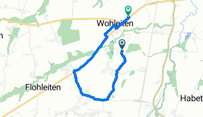
Unterbreitenried 31 nach Wohleiten 8
A cycling route starting in Ried im Innkreis, Upper Austria, Austria.
Overview
About this route
- 37 min
- Duration
- 3 km
- Distance
- 44 m
- Ascent
- 46 m
- Descent
- 5 km/h
- Avg. speed
- ---
- Max. altitude

Route quality
Waytypes & surfaces along the route
Waytypes
Quiet road
2 km
(66 %)
Access road
0 km
(1 %)
Undefined
1 km
(33 %)
Surfaces
Paved
0.8 km
(25 %)
Asphalt
0.8 km
(25 %)
Undefined
2.3 km
(75 %)
Continue with Bikemap
Use, edit, or download this cycling route
You would like to ride Unterbreitenried 31 nach Wohleiten 8 or customize it for your own trip? Here is what you can do with this Bikemap route:
Free features
- Save this route as favorite or in collections
- Copy & plan your own version of this route
- Sync your route with Garmin or Wahoo
Premium features
Free trial for 3 days, or one-time payment. More about Bikemap Premium.
- Navigate this route on iOS & Android
- Export a GPX / KML file of this route
- Create your custom printout (try it for free)
- Download this route for offline navigation
Discover more Premium features.
Get Bikemap PremiumFrom our community
Other popular routes starting in Ried im Innkreis
 Noxberg
- Distance
- 26.1 km
- Ascent
- 336 m
- Descent
- 336 m
- Location
- Ried im Innkreis, Upper Austria, Austria
 Hausrucktour 1
- Distance
- 57.4 km
- Ascent
- 527 m
- Descent
- 530 m
- Location
- Ried im Innkreis, Upper Austria, Austria
 Von der Pram zum Inn und zurück
- Distance
- 78.5 km
- Ascent
- 527 m
- Descent
- 508 m
- Location
- Ried im Innkreis, Upper Austria, Austria
 Ried - Wildenau
- Distance
- 14.7 km
- Ascent
- 204 m
- Descent
- 229 m
- Location
- Ried im Innkreis, Upper Austria, Austria
 Noxberg - Extended
- Distance
- 31.8 km
- Ascent
- 360 m
- Descent
- 360 m
- Location
- Ried im Innkreis, Upper Austria, Austria
 Pram - Taufkirchen an der Trattnach - Zell an der Pram. 🚴♂️🚴
- Distance
- 47 km
- Ascent
- 866 m
- Descent
- 864 m
- Location
- Ried im Innkreis, Upper Austria, Austria
 Innviertel Runde
- Distance
- 36.7 km
- Ascent
- 304 m
- Descent
- 304 m
- Location
- Ried im Innkreis, Upper Austria, Austria
 Umrundung von Ried im Innkreis
- Distance
- 57.7 km
- Ascent
- 560 m
- Descent
- 561 m
- Location
- Ried im Innkreis, Upper Austria, Austria
Open it in the app