

Krug oko jezera + Zahum
A cycling route starting in Rumboci, Federation of Bosnia and Herzegovina, Bosnia and Herzegovina.
Overview
About this route
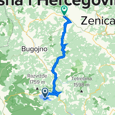
The start of this route is at the parking lot of the Franciscan Monastery Rama-Šćit, next to the Rama Rowing Center in the village of Šćit on the lakeshore. The total length of the route is 58.1 km. After a short ride through the villages of Šćit and Ripci, the route continues on the regional road Prozor – Tomislavgrad, then descends after 3 km to the shore of Ramsko Lake, passing through the villages of Podbor, Ploča, and Mluša. The route crosses the dam of the Rama Hydroelectric Power Plant to the villages of Maglice and Orašac, with a challenging 4 km climb offering views of Ramsko Lake. The route then follows the regional road Prozor – Tomislavgrad to the turnoff for the mountain village Zahum. After 4 km, you reach the 'Rama Viewpoint,' a spot that offers the most beautiful view of the entire Rama valley and stunning scenery, with Ramsko Lake in the foreground like on the palm of your hand. The return from the viewpoint follows the same path to the turnoff to the village of Varvara and the descent to the shore of Ramsko Lake. Along the shore, you ride 5 km on the pilgrimage trail 'Staza Gospi Sinjskoj' and return to Šćit. During 90% of the ride, you can enjoy views of the beautiful landscape dominated by Ramsko Lake.
- -:--
- Duration
- 58.2 km
- Distance
- 1,292 m
- Ascent
- 1,293 m
- Descent
- ---
- Avg. speed
- ---
- Max. altitude

Route quality
Waytypes & surfaces along the route
Waytypes
Road
22.1 km
(38 %)
Quiet road
18.6 km
(32 %)
Surfaces
Paved
29.1 km
(50 %)
Unpaved
8.7 km
(15 %)
Asphalt
29.1 km
(50 %)
Gravel
4.7 km
(8 %)
Continue with Bikemap
Use, edit, or download this cycling route
You would like to ride Krug oko jezera + Zahum or customize it for your own trip? Here is what you can do with this Bikemap route:
Free features
- Save this route as favorite or in collections
- Copy & plan your own version of this route
- Sync your route with Garmin or Wahoo
Premium features
Free trial for 3 days, or one-time payment. More about Bikemap Premium.
- Navigate this route on iOS & Android
- Export a GPX / KML file of this route
- Create your custom printout (try it for free)
- Download this route for offline navigation
Discover more Premium features.
Get Bikemap PremiumFrom our community
Other popular routes starting in Rumboci
 Krug oko jezera + Zahum
- Distance
- 58.2 km
- Ascent
- 1,292 m
- Descent
- 1,293 m
- Location
- Rumboci, Federation of Bosnia and Herzegovina, Bosnia and Herzegovina
 2. Tag Scit-Mostar 24.05.
- Distance
- 99.5 km
- Ascent
- 1,497 m
- Descent
- 2,053 m
- Location
- Rumboci, Federation of Bosnia and Herzegovina, Bosnia and Herzegovina
 DZIEN 10
- Distance
- 309 km
- Ascent
- 2,421 m
- Descent
- 3,022 m
- Location
- Rumboci, Federation of Bosnia and Herzegovina, Bosnia and Herzegovina
 Krug oko ramskog jezera
- Distance
- 33.1 km
- Ascent
- 823 m
- Descent
- 819 m
- Location
- Rumboci, Federation of Bosnia and Herzegovina, Bosnia and Herzegovina
 Ramsko Blidinje
- Distance
- 94 km
- Ascent
- 1,677 m
- Descent
- 1,666 m
- Location
- Rumboci, Federation of Bosnia and Herzegovina, Bosnia and Herzegovina
 Unnamed Road to Unnamed Road
- Distance
- 57.6 km
- Ascent
- 1,029 m
- Descent
- 1,028 m
- Location
- Rumboci, Federation of Bosnia and Herzegovina, Bosnia and Herzegovina
 Rama -Pločno
- Distance
- 53.9 km
- Ascent
- 1,788 m
- Descent
- 495 m
- Location
- Rumboci, Federation of Bosnia and Herzegovina, Bosnia and Herzegovina
 TS - SA 007 : LAGO RAMA - TRAVNIK
- Distance
- 79.7 km
- Ascent
- 987 m
- Descent
- 1,105 m
- Location
- Rumboci, Federation of Bosnia and Herzegovina, Bosnia and Herzegovina
Open it in the app