
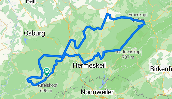
Tag-4_Kell-Erbeskopf
A cycling route starting in Kell, Rhineland-Palatinate, Germany.
Overview
About this route
- -:--
- Duration
- 80.3 km
- Distance
- 961 m
- Ascent
- 960 m
- Descent
- ---
- Avg. speed
- ---
- Max. altitude

Route quality
Waytypes & surfaces along the route
Waytypes
Road
21.1 km
(26 %)
Busy road
18.7 km
(23 %)
Surfaces
Paved
77.5 km
(97 %)
Unpaved
0.3 km
(<1 %)
Asphalt
66.5 km
(83 %)
Paved (undefined)
10.4 km
(13 %)
Continue with Bikemap
Use, edit, or download this cycling route
You would like to ride Tag-4_Kell-Erbeskopf or customize it for your own trip? Here is what you can do with this Bikemap route:
Free features
- Save this route as favorite or in collections
- Copy & plan your own version of this route
- Split it into stages to create a multi-day tour
- Sync your route with Garmin or Wahoo
Premium features
Free trial for 3 days, or one-time payment. More about Bikemap Premium.
- Navigate this route on iOS & Android
- Export a GPX / KML file of this route
- Create your custom printout (try it for free)
- Download this route for offline navigation
Discover more Premium features.
Get Bikemap PremiumFrom our community
Other popular routes starting in Kell
 RLP5: Kell am See - Mettendorf 83km 760hm
- Distance
- 83.2 km
- Ascent
- 514 m
- Descent
- 743 m
- Location
- Kell, Rhineland-Palatinate, Germany
 Tag-4_Kell-Erbeskopf
- Distance
- 80.3 km
- Ascent
- 961 m
- Descent
- 960 m
- Location
- Kell, Rhineland-Palatinate, Germany
 Feriendorf Hochwald 166, Kell am See nach Feriendorf Hochwald 158, Kell am See
- Distance
- 23.4 km
- Ascent
- 425 m
- Descent
- 412 m
- Location
- Kell, Rhineland-Palatinate, Germany
 Kell am See - Hermeskeil / WASGAU Markt - Retour
- Distance
- 31 km
- Ascent
- 315 m
- Descent
- 320 m
- Location
- Kell, Rhineland-Palatinate, Germany
 Tag-3_Kell-Saar-Losheim
- Distance
- 87.3 km
- Ascent
- 945 m
- Descent
- 943 m
- Location
- Kell, Rhineland-Palatinate, Germany
 Kell am See - Hochwald - Tour
- Distance
- 30.4 km
- Ascent
- 647 m
- Descent
- 641 m
- Location
- Kell, Rhineland-Palatinate, Germany
 Tag-1_Kelltrasse kurz
- Distance
- 34.5 km
- Ascent
- 490 m
- Descent
- 475 m
- Location
- Kell, Rhineland-Palatinate, Germany
 Domenica Tour del bosco alto 😎
- Distance
- 32.5 km
- Ascent
- 632 m
- Descent
- 634 m
- Location
- Kell, Rhineland-Palatinate, Germany
Open it in the app