

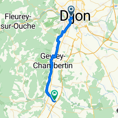
Toul Le-Puy Etappe 4 Dijon Beaune
A cycling route starting in Dijon, Bourgogne-Franche-Comté, France.
Overview
About this route
Geplanter Santiagopilgerweg nach Hinweisen für Radfahrer:
Dumont-aktiv
Wandern auf dem Jakobsweg von Trier nach Le Puy
- -:--
- Duration
- 43.7 km
- Distance
- 132 m
- Ascent
- 164 m
- Descent
- ---
- Avg. speed
- ---
- Max. altitude
Route quality
Waytypes & surfaces along the route
Waytypes
Road
21.9 km
(50 %)
Quiet road
14.4 km
(33 %)
Surfaces
Paved
26.5 km
(61 %)
Asphalt
26.2 km
(60 %)
Paving stones
0.3 km
(<1 %)
Undefined
17.3 km
(39 %)
Continue with Bikemap
Use, edit, or download this cycling route
You would like to ride Toul Le-Puy Etappe 4 Dijon Beaune or customize it for your own trip? Here is what you can do with this Bikemap route:
Free features
- Save this route as favorite or in collections
- Copy & plan your own version of this route
- Sync your route with Garmin or Wahoo
Premium features
Free trial for 3 days, or one-time payment. More about Bikemap Premium.
- Navigate this route on iOS & Android
- Export a GPX / KML file of this route
- Create your custom printout (try it for free)
- Download this route for offline navigation
Discover more Premium features.
Get Bikemap PremiumFrom our community
Other popular routes starting in Dijon
 De Cour de la gare à La Berchère
- Distance
- 26.6 km
- Ascent
- 157 m
- Descent
- 168 m
- Location
- Dijon, Bourgogne-Franche-Comté, France
 Girolibero Digione–Montbeliard
- Distance
- 251 km
- Ascent
- 421 m
- Descent
- 352 m
- Location
- Dijon, Bourgogne-Franche-Comté, France
 Dijon-Pasques-Val-Suzon
- Distance
- 49.9 km
- Ascent
- 573 m
- Descent
- 482 m
- Location
- Dijon, Bourgogne-Franche-Comté, France
 Dijon - Môtiers
- Distance
- 192.7 km
- Ascent
- 2,289 m
- Descent
- 1,801 m
- Location
- Dijon, Bourgogne-Franche-Comté, France
 Tour 4 maggio
- Distance
- 67.2 km
- Ascent
- 448 m
- Descent
- 468 m
- Location
- Dijon, Bourgogne-Franche-Comté, France
 Toul Le-Puy Etappe 4 Dijon Beaune
- Distance
- 43.7 km
- Ascent
- 132 m
- Descent
- 164 m
- Location
- Dijon, Bourgogne-Franche-Comté, France
 Girolibero: Il canale di Borgogna / Da Digione a Auxerre
- Distance
- 241.9 km
- Ascent
- 212 m
- Descent
- 364 m
- Location
- Dijon, Bourgogne-Franche-Comté, France
 Plattelandsrit vanuit Dijon
- Distance
- 39.6 km
- Ascent
- 516 m
- Descent
- 515 m
- Location
- Dijon, Bourgogne-Franche-Comté, France
Open it in the app