

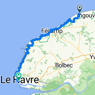
Saint-Valery-en-Caux - Fécamp
A cycling route starting in Saint-Valery-en-Caux, Normandy, France.
Overview
About this route
- 4 h 34 min
- Duration
- 44.7 km
- Distance
- 365 m
- Ascent
- 365 m
- Descent
- 9.8 km/h
- Avg. speed
- ---
- Max. altitude

Route photos


Route quality
Waytypes & surfaces along the route
Waytypes
Road
25.1 km
(56 %)
Quiet road
6.3 km
(14 %)
Surfaces
Paved
37 km
(83 %)
Unpaved
0.5 km
(1 %)
Asphalt
36.6 km
(82 %)
Ground
0.5 km
(1 %)
Continue with Bikemap
Use, edit, or download this cycling route
You would like to ride Saint-Valery-en-Caux - Fécamp or customize it for your own trip? Here is what you can do with this Bikemap route:
Free features
- Save this route as favorite or in collections
- Copy & plan your own version of this route
- Sync your route with Garmin or Wahoo
Premium features
Free trial for 3 days, or one-time payment. More about Bikemap Premium.
- Navigate this route on iOS & Android
- Export a GPX / KML file of this route
- Create your custom printout (try it for free)
- Download this route for offline navigation
Discover more Premium features.
Get Bikemap PremiumFrom our community
Other popular routes starting in Saint-Valery-en-Caux
 Etape 2 : Veules - Sassetot ( done )
- Distance
- 35.7 km
- Ascent
- 346 m
- Descent
- 296 m
- Location
- Saint-Valery-en-Caux, Normandy, France
 St-Valery-en-Caux - Etretat Etappe 6
- Distance
- 57.1 km
- Ascent
- 536 m
- Descent
- 528 m
- Location
- Saint-Valery-en-Caux, Normandy, France
 Saint-Valery-en-Caux - Fécamp
- Distance
- 44.7 km
- Ascent
- 365 m
- Descent
- 365 m
- Location
- Saint-Valery-en-Caux, Normandy, France
 TMS Veules Etretat
- Distance
- 73.4 km
- Ascent
- 415 m
- Descent
- 432 m
- Location
- Saint-Valery-en-Caux, Normandy, France
 Ste Valery en Caux - Dieppe
- Distance
- 34.9 km
- Ascent
- 346 m
- Descent
- 343 m
- Location
- Saint-Valery-en-Caux, Normandy, France
 2 etretat
- Distance
- 68 km
- Ascent
- 390 m
- Descent
- 427 m
- Location
- Saint-Valery-en-Caux, Normandy, France
 a-TF07 Veulettes sur Mer- Le Havre
- Distance
- 86.8 km
- Ascent
- 969 m
- Descent
- 965 m
- Location
- Saint-Valery-en-Caux, Normandy, France
 Fécamp / Saint-Valery-en-Caux
- Distance
- 41.5 km
- Ascent
- 0 m
- Descent
- 0 m
- Location
- Saint-Valery-en-Caux, Normandy, France
Open it in the app