

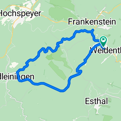
weidenthal - esthal - weidenthal
A cycling route starting in Weidenthal, Rhineland-Palatinate, Germany.
Overview
About this route
weidenthal - gelb/rot - estahl - weiß/grün - weidenthal
- -:--
- Duration
- 13.5 km
- Distance
- 402 m
- Ascent
- 401 m
- Descent
- ---
- Avg. speed
- ---
- Max. altitude

Route quality
Waytypes & surfaces along the route
Waytypes
Track
8.3 km
(61 %)
Path
4 km
(29 %)
Surfaces
Paved
1.2 km
(9 %)
Unpaved
9.8 km
(73 %)
Unpaved (undefined)
4.1 km
(31 %)
Gravel
3.1 km
(23 %)
Continue with Bikemap
Use, edit, or download this cycling route
You would like to ride weidenthal - esthal - weidenthal or customize it for your own trip? Here is what you can do with this Bikemap route:
Free features
- Save this route as favorite or in collections
- Copy & plan your own version of this route
- Sync your route with Garmin or Wahoo
Premium features
Free trial for 3 days, or one-time payment. More about Bikemap Premium.
- Navigate this route on iOS & Android
- Export a GPX / KML file of this route
- Create your custom printout (try it for free)
- Download this route for offline navigation
Discover more Premium features.
Get Bikemap PremiumFrom our community
Other popular routes starting in Weidenthal
 2012 Saupferch-Drachenfels
- Distance
- 5.8 km
- Ascent
- 363 m
- Descent
- 82 m
- Location
- Weidenthal, Rhineland-Palatinate, Germany
 B39 Morschbacherhof Esthal Breitenstein
- Distance
- 11.8 km
- Ascent
- 305 m
- Descent
- 336 m
- Location
- Weidenthal, Rhineland-Palatinate, Germany
 Gemütliche Fahrt
- Distance
- 23.1 km
- Ascent
- 523 m
- Descent
- 530 m
- Location
- Weidenthal, Rhineland-Palatinate, Germany
 Track 001
- Distance
- 10.6 km
- Ascent
- 401 m
- Descent
- 401 m
- Location
- Weidenthal, Rhineland-Palatinate, Germany
 Weidenthal 1
- Distance
- 7.2 km
- Ascent
- 256 m
- Descent
- 253 m
- Location
- Weidenthal, Rhineland-Palatinate, Germany
 Drachenfels - Neustadt
- Distance
- 17.6 km
- Ascent
- 208 m
- Descent
- 626 m
- Location
- Weidenthal, Rhineland-Palatinate, Germany
 Saupferch - Drachenfels
- Distance
- 15.9 km
- Ascent
- 570 m
- Descent
- 576 m
- Location
- Weidenthal, Rhineland-Palatinate, Germany
 NW - Eiswoog - NW
- Distance
- 65.5 km
- Ascent
- 722 m
- Descent
- 735 m
- Location
- Weidenthal, Rhineland-Palatinate, Germany
Open it in the app