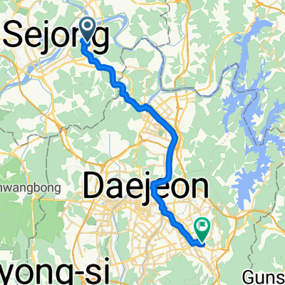
210-59 Sinseong-dong, Yuseong-gu to 178-398 Eojin-dong, Sejong-si
A cycling route starting in Songgangdong, Daejeon, South Korea.
Overview
About this route
- 2 h 14 min
- Duration
- 20 km
- Distance
- 144 m
- Ascent
- 180 m
- Descent
- 9 km/h
- Avg. speed
- ---
- Max. altitude
Continue with Bikemap
Use, edit, or download this cycling route
You would like to ride 210-59 Sinseong-dong, Yuseong-gu to 178-398 Eojin-dong, Sejong-si or customize it for your own trip? Here is what you can do with this Bikemap route:
Free features
- Save this route as favorite or in collections
- Copy & plan your own version of this route
- Sync your route with Garmin or Wahoo
Premium features
Free trial for 3 days, or one-time payment. More about Bikemap Premium.
- Navigate this route on iOS & Android
- Export a GPX / KML file of this route
- Create your custom printout (try it for free)
- Download this route for offline navigation
Discover more Premium features.
Get Bikemap PremiumFrom our community
Other popular routes starting in Songgangdong
- 세종보-대청댐
- Distance
- 34.2 km
- Ascent
- 170 m
- Descent
- 133 m
- Location
- Songgangdong, Daejeon, South Korea
- 충대뒷산 ~ 침신대 싱글 2/2
- Distance
- 10.6 km
- Ascent
- 220 m
- Descent
- 247 m
- Location
- Songgangdong, Daejeon, South Korea
- 와동 장동 신탄진 싱글 라이딩
- Distance
- 18.4 km
- Ascent
- 561 m
- Descent
- 543 m
- Location
- Songgangdong, Daejeon, South Korea
- 유성 ~ 비학산 ~ 금병산
- Distance
- 32.4 km
- Ascent
- 983 m
- Descent
- 963 m
- Location
- Songgangdong, Daejeon, South Korea
- Ocheon Bicycle Path (Final)
- Distance
- 98.2 km
- Ascent
- 376 m
- Descent
- 163 m
- Location
- Songgangdong, Daejeon, South Korea
- Ph0]에서 경로연기면 548-85
- Distance
- 36.2 km
- Ascent
- 121 m
- Descent
- 119 m
- Location
- Songgangdong, Daejeon, South Korea
- 지족산 싱글
- Distance
- 12.4 km
- Ascent
- 432 m
- Descent
- 399 m
- Location
- Songgangdong, Daejeon, South Korea
- 햇무리교-세종호수공원-이응다리
- Distance
- 16.1 km
- Ascent
- 43 m
- Descent
- 39 m
- Location
- Songgangdong, Daejeon, South Korea
Open it in the app