

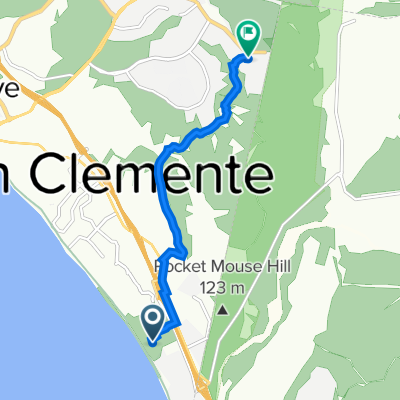
1624 N El Camino Real, San Clemente to 24882–24898 Dana Point Harbor Dr, Dana Point
A cycling route starting in San Clemente, California, United States.
Overview
About this route
- 1 h 8 min
- Duration
- 10.8 km
- Distance
- 6 m
- Ascent
- 21 m
- Descent
- 9.5 km/h
- Avg. speed
- ---
- Max. altitude
Route quality
Waytypes & surfaces along the route
Waytypes
Cycleway
4.9 km
(45 %)
Quiet road
2.7 km
(25 %)
Surfaces
Paved
8.7 km
(81 %)
Asphalt
8.7 km
(81 %)
Undefined
2 km
(19 %)
Continue with Bikemap
Use, edit, or download this cycling route
You would like to ride 1624 N El Camino Real, San Clemente to 24882–24898 Dana Point Harbor Dr, Dana Point or customize it for your own trip? Here is what you can do with this Bikemap route:
Free features
- Save this route as favorite or in collections
- Copy & plan your own version of this route
- Sync your route with Garmin or Wahoo
Premium features
Free trial for 3 days, or one-time payment. More about Bikemap Premium.
- Navigate this route on iOS & Android
- Export a GPX / KML file of this route
- Create your custom printout (try it for free)
- Download this route for offline navigation
Discover more Premium features.
Get Bikemap PremiumFrom our community
Other popular routes starting in San Clemente
 100 Avenida Presidio, San Clemente to Second Ave, San Diego
- Distance
- 101.1 km
- Ascent
- 423 m
- Descent
- 497 m
- Location
- San Clemente, California, United States
 San Clemente to241 Avenida la Pata, San Clemente
- Distance
- 6.7 km
- Ascent
- 266 m
- Descent
- 124 m
- Location
- San Clemente, California, United States
 1624 N El Camino Real, San Clemente to 24882–24898 Dana Point Harbor Dr, Dana Point
- Distance
- 10.8 km
- Ascent
- 6 m
- Descent
- 21 m
- Location
- San Clemente, California, United States
 Sanooo
- Distance
- 18.9 km
- Ascent
- 145 m
- Descent
- 146 m
- Location
- San Clemente, California, United States
 Brew Ride
- Distance
- 38.2 km
- Ascent
- 390 m
- Descent
- 437 m
- Location
- San Clemente, California, United States
 bike tour from San Clemente to Dana Point
- Distance
- 14.9 km
- Ascent
- 137 m
- Descent
- 151 m
- Location
- San Clemente, California, United States
 High-speed route in San Clemente
- Distance
- 32.7 km
- Ascent
- 281 m
- Descent
- 419 m
- Location
- San Clemente, California, United States
 Recovered Route
- Distance
- 11.5 km
- Ascent
- 0 m
- Descent
- 3 m
- Location
- San Clemente, California, United States
Open it in the app