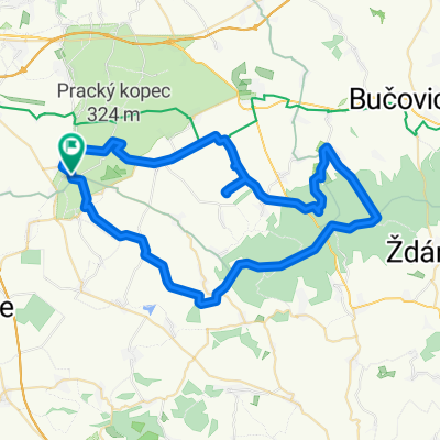
telnice - zdanicky les
A cycling route starting in Sokolnice, South Moravian, Czechia.
Overview
About this route
minimálně po silnici
- -:--
- Duration
- 61.4 km
- Distance
- 586 m
- Ascent
- 591 m
- Descent
- ---
- Avg. speed
- ---
- Max. altitude
Continue with Bikemap
Use, edit, or download this cycling route
You would like to ride telnice - zdanicky les or customize it for your own trip? Here is what you can do with this Bikemap route:
Free features
- Save this route as favorite or in collections
- Copy & plan your own version of this route
- Sync your route with Garmin or Wahoo
Premium features
Free trial for 3 days, or one-time payment. More about Bikemap Premium.
- Navigate this route on iOS & Android
- Export a GPX / KML file of this route
- Create your custom printout (try it for free)
- Download this route for offline navigation
Discover more Premium features.
Get Bikemap PremiumFrom our community
Other popular routes starting in Sokolnice
- mmahut: Sokolnicky Balaton
- Distance
- 4.9 km
- Ascent
- 4 m
- Descent
- 25 m
- Location
- Sokolnice, South Moravian, Czechia
- cyklomaraton K24
- Distance
- 28 km
- Ascent
- 83 m
- Descent
- 78 m
- Location
- Sokolnice, South Moravian, Czechia
- Cyklomaraton K24 2009
- Distance
- 28 km
- Ascent
- 84 m
- Descent
- 81 m
- Location
- Sokolnice, South Moravian, Czechia
- Tuřany - Ivančice - Jamolice a zpět
- Distance
- 83.7 km
- Ascent
- 539 m
- Descent
- 539 m
- Location
- Sokolnice, South Moravian, Czechia
- telnice - zdanicky les
- Distance
- 61.4 km
- Ascent
- 586 m
- Descent
- 591 m
- Location
- Sokolnice, South Moravian, Czechia
- 22.6.2012
- Distance
- 274.1 km
- Ascent
- 149 m
- Descent
- 149 m
- Location
- Sokolnice, South Moravian, Czechia
- Sokolnice - Kalečník
- Distance
- 34.5 km
- Ascent
- 592 m
- Descent
- 292 m
- Location
- Sokolnice, South Moravian, Czechia
- Sokolnice - Muchova Bouda
- Distance
- 16.1 km
- Ascent
- 175 m
- Descent
- 81 m
- Location
- Sokolnice, South Moravian, Czechia
Open it in the app