

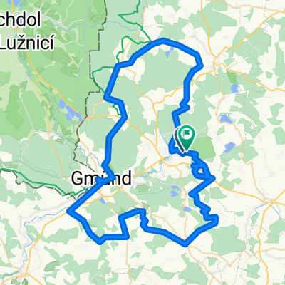
Langegg - Litschau - Langegg
A cycling route starting in Schrems, Lower Austria, Austria.
Overview
About this route
Langegg - Steinbach - Neu-Nagelberg - Alt-Nagelberg - Brand - Litschau - Eisgarn - Heidenreichstein - Kl. Pertholz - Aalfang - Langegg
- -:--
- Duration
- 42.5 km
- Distance
- 422 m
- Ascent
- 432 m
- Descent
- ---
- Avg. speed
- 615 m
- Max. altitude
Route quality
Waytypes & surfaces along the route
Waytypes
Road
3.4 km
(8 %)
Quiet road
2.5 km
(6 %)
Surfaces
Paved
5.5 km
(13 %)
Asphalt
5.5 km
(13 %)
Undefined
36.9 km
(87 %)
Continue with Bikemap
Use, edit, or download this cycling route
You would like to ride Langegg - Litschau - Langegg or customize it for your own trip? Here is what you can do with this Bikemap route:
Free features
- Save this route as favorite or in collections
- Copy & plan your own version of this route
- Sync your route with Garmin or Wahoo
Premium features
Free trial for 3 days, or one-time payment. More about Bikemap Premium.
- Navigate this route on iOS & Android
- Export a GPX / KML file of this route
- Create your custom printout (try it for free)
- Download this route for offline navigation
Discover more Premium features.
Get Bikemap PremiumFrom our community
Other popular routes starting in Schrems
 Wandertag 2022
- Distance
- 5 km
- Ascent
- 51 m
- Descent
- 50 m
- Location
- Schrems, Lower Austria, Austria
 Langegg - Litschau - Langegg
- Distance
- 42.5 km
- Ascent
- 422 m
- Descent
- 432 m
- Location
- Schrems, Lower Austria, Austria
 Wasserlandschaftsradweg
- Distance
- 89.1 km
- Ascent
- 883 m
- Descent
- 883 m
- Location
- Schrems, Lower Austria, Austria
 Waldviertler Wasserlandschaftsradweg
- Distance
- 76.4 km
- Ascent
- 759 m
- Descent
- 760 m
- Location
- Schrems, Lower Austria, Austria
 Schrems-Ludwigsthal
- Distance
- 16 km
- Ascent
- 205 m
- Descent
- 225 m
- Location
- Schrems, Lower Austria, Austria
 Schrems - Brand - Schrems - abseits der Straße
- Distance
- 22.2 km
- Ascent
- 228 m
- Descent
- 232 m
- Location
- Schrems, Lower Austria, Austria
 La-Hstein-WT-Vit-GrGlobn-Kb-Schr-Eug-La
- Distance
- 65.9 km
- Ascent
- 553 m
- Descent
- 569 m
- Location
- Schrems, Lower Austria, Austria
 Kleine Schremser Waldrunde #2
- Distance
- 18.9 km
- Ascent
- 248 m
- Descent
- 248 m
- Location
- Schrems, Lower Austria, Austria
Open it in the app