- 29.6 km
- 141 m
- 139 m
- Sauerlach, Bavaria, Germany
Walchstatt-Peretshofen-Walchstatt
A cycling route starting in Sauerlach, Bavaria, Germany.
Overview
About this route
Cycling tour on 16.01.2011
Walchstatt
Sauerlach
Großeichenhausen
Attenham
Wörschhausen
Thanning
Moosham
Schalkofen
Siegertshofen
Weihermühle
Podling
Peretshofen
Rampertshofen
Bairawies
Hechenberg
Walleiten
Obermühltal
Dietramszell
Dietenhausen
Thalham
Jasberg
Palnkam
Otterfing
Hofolding
Brunnthal
Otterloh
Walchstatt
- -:--
- Duration
- 64.8 km
- Distance
- 433 m
- Ascent
- 433 m
- Descent
- ---
- Avg. speed
- ---
- Max. altitude
created this 15 years ago
Route quality
Waytypes & surfaces along the route
Waytypes
Quiet road
40.2 km
62 %
Road
5.2 km
8 %
Surfaces
Paved
57 km
(88 %)
Unpaved
4.5 km
(7 %)
Asphalt
56.4 km
87 %
Unpaved (undefined)
2.6 km
4 %
Continue with Bikemap
Use, edit, or download this cycling route
You would like to ride Walchstatt-Peretshofen-Walchstatt or customize it for your own trip? Here is what you can do with this Bikemap route:
Free features
- Save this route as favorite or in collections
- Copy & plan your own version of this route
- Sync your route with Garmin or Wahoo
Premium features
Free trial for 3 days, or one-time payment. More about Bikemap Premium.
- Navigate this route on iOS & Android
- Export a GPX / KML file of this route
- Create your custom printout (try it for free)
- Download this route for offline navigation
Discover more Premium features.
Get Bikemap PremiumFrom our community
Other popular routes starting in Sauerlach
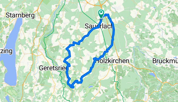
- Kirchstraße, Sauerlach nach Kirchstraße, Sauerlach
- Deininger Weiher
- 14.6 km
- 134 m
- 124 m
- Sauerlach, Bavaria, Germany
- Isar-Kanal
- 58 km
- 229 m
- 229 m
- Sauerlach, Bavaria, Germany
- Deisenhofener Straße, Sauerlach nach Bad Dürkheimer Weg, Kempten (Allgäu)
- 146.6 km
- 1,318 m
- 1,223 m
- Sauerlach, Bavaria, Germany
- Menterschwaige
- 38.3 km
- 97 m
- 97 m
- Sauerlach, Bavaria, Germany
- Walchstatt-Schmidham
- 71 km
- 0 m
- 0 m
- Sauerlach, Bavaria, Germany
- Sauerlach - Shell, Holzkirchen
- 118.1 km
- 1,748 m
- 1,683 m
- Sauerlach, Bavaria, Germany
- Walchensee
- 133.9 km
- 630 m
- 630 m
- Sauerlach, Bavaria, Germany
Open it in the app


