
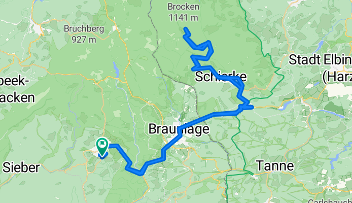
St Andreasberg - Brocken - St Andreasberg
A cycling route starting in Sankt Andreasberg, Lower Saxony, Germany.
Overview
About this route
Asvaltering op de Brocken valt wel wat over te zeggen. De afdaling is daarom niet echt racefiets vriendelijk.
- -:--
- Duration
- 69.8 km
- Distance
- 1,292 m
- Ascent
- 1,295 m
- Descent
- ---
- Avg. speed
- ---
- Max. altitude

Route quality
Waytypes & surfaces along the route
Waytypes
Quiet road
18.8 km
(27 %)
Track
8.4 km
(12 %)
Surfaces
Paved
56.5 km
(81 %)
Unpaved
4.2 km
(6 %)
Asphalt
56.5 km
(81 %)
Loose gravel
2.1 km
(3 %)
Route highlights
Points of interest along the route
Point of interest after 33.8 km
Continue with Bikemap
Use, edit, or download this cycling route
You would like to ride St Andreasberg - Brocken - St Andreasberg or customize it for your own trip? Here is what you can do with this Bikemap route:
Free features
- Save this route as favorite or in collections
- Copy & plan your own version of this route
- Sync your route with Garmin or Wahoo
Premium features
Free trial for 3 days, or one-time payment. More about Bikemap Premium.
- Navigate this route on iOS & Android
- Export a GPX / KML file of this route
- Create your custom printout (try it for free)
- Download this route for offline navigation
Discover more Premium features.
Get Bikemap PremiumFrom our community
Other popular routes starting in Sankt Andreasberg
 2008/10_Von St. Andreasberg über Oderteich und Wolfswarte zum Acker
- Distance
- 36.4 km
- Ascent
- 730 m
- Descent
- 735 m
- Location
- Sankt Andreasberg, Lower Saxony, Germany
 Góry Harc 07 września 2011
- Distance
- 86.5 km
- Ascent
- 0 m
- Descent
- 0 m
- Location
- Sankt Andreasberg, Lower Saxony, Germany
 St Andreasberg - Brocken - St Andreasberg
- Distance
- 69.8 km
- Ascent
- 1,292 m
- Descent
- 1,295 m
- Location
- Sankt Andreasberg, Lower Saxony, Germany
 Harztour 03.05.2010
- Distance
- 52.3 km
- Ascent
- 1,170 m
- Descent
- 1,170 m
- Location
- Sankt Andreasberg, Lower Saxony, Germany
 Kleine Harzrunde St. Andreasberg - Wernigerode
- Distance
- 108.6 km
- Ascent
- 1,334 m
- Descent
- 1,334 m
- Location
- Sankt Andreasberg, Lower Saxony, Germany
 MTB Sankt Andreasberg Rundkurs
- Distance
- 56.9 km
- Ascent
- 1,068 m
- Descent
- 1,070 m
- Location
- Sankt Andreasberg, Lower Saxony, Germany
 RTF - Grosse Ostharztour
- Distance
- 113 km
- Ascent
- 1,223 m
- Descent
- 1,247 m
- Location
- Sankt Andreasberg, Lower Saxony, Germany
 Oderstausee-Brocken
- Distance
- 46.7 km
- Ascent
- 905 m
- Descent
- 904 m
- Location
- Sankt Andreasberg, Lower Saxony, Germany
Open it in the app