

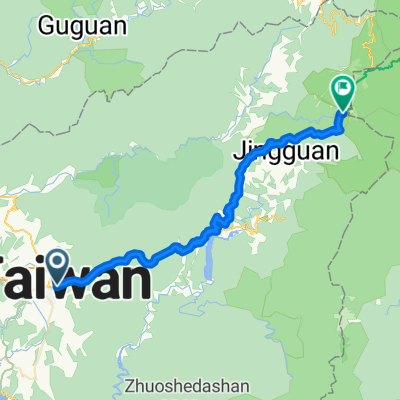
**136線國姓 太平**
A cycling route starting in Puli, Taiwan, Taiwan.
Overview
About this route
- -:--
- Duration
- 26.4 km
- Distance
- 594 m
- Ascent
- 722 m
- Descent
- ---
- Avg. speed
- ---
- Max. altitude

Route quality
Waytypes & surfaces along the route
Waytypes
Quiet road
0.5 km
(2 %)
Track
0.5 km
(2 %)
Surfaces
Paved
0.8 km
(3 %)
Concrete
0.5 km
(2 %)
Asphalt
0.3 km
(1 %)
Undefined
25.6 km
(97 %)
Continue with Bikemap
Use, edit, or download this cycling route
You would like to ride **136線國姓 太平** or customize it for your own trip? Here is what you can do with this Bikemap route:
Free features
- Save this route as favorite or in collections
- Copy & plan your own version of this route
- Sync your route with Garmin or Wahoo
Premium features
Free trial for 3 days, or one-time payment. More about Bikemap Premium.
- Navigate this route on iOS & Android
- Export a GPX / KML file of this route
- Create your custom printout (try it for free)
- Download this route for offline navigation
Discover more Premium features.
Get Bikemap PremiumFrom our community
Other popular routes starting in Puli
 埔里武界奧萬大霧社埔里繞圈
- Distance
- 69.7 km
- Ascent
- 1,500 m
- Descent
- 1,500 m
- Location
- Puli, Taiwan, Taiwan
 <慢騎>環日月潭991226
- Distance
- 29.4 km
- Ascent
- 520 m
- Descent
- 520 m
- Location
- Puli, Taiwan, Taiwan
 挑戰武嶺
挑戰武嶺- Distance
- 52.7 km
- Ascent
- 3,880 m
- Descent
- 1,274 m
- Location
- Puli, Taiwan, Taiwan
 埔里國中→武嶺55km超級坡挑戰賽
- Distance
- 54.6 km
- Ascent
- 2,833 m
- Descent
- 18 m
- Location
- Puli, Taiwan, Taiwan
 日月潭環湖
日月潭環湖- Distance
- 31.3 km
- Ascent
- 1,307 m
- Descent
- 1,294 m
- Location
- Puli, Taiwan, Taiwan
 埔里至武嶺
埔里至武嶺- Distance
- 53 km
- Ascent
- 3,534 m
- Descent
- 1,546 m
- Location
- Puli, Taiwan, Taiwan
 20100530 第二屆 武嶺高峰會
- Distance
- 51.8 km
- Ascent
- 2,875 m
- Descent
- 93 m
- Location
- Puli, Taiwan, Taiwan
 埔里到武嶺
埔里到武嶺- Distance
- 53.8 km
- Ascent
- 3,442 m
- Descent
- 1,313 m
- Location
- Puli, Taiwan, Taiwan
Open it in the app