

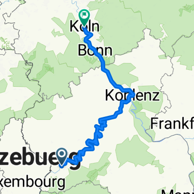
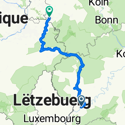
Deutsch-Luxemburgische Permanente 2014 - 96 km Perm. des RV Schwalbe Trier 1932 e.V.
A cycling route starting in Trier, Rhineland-Palatinate, Germany.
Overview
About this route
Deutsch-Luxembourg Permanent 2014 - 96 km
Permanent RTF from RV Schwalbe Trier 1932 e.V.
All further information about this route -> click here
- -:--
- Duration
- 98.4 km
- Distance
- 312 m
- Ascent
- 310 m
- Descent
- ---
- Avg. speed
- ---
- Max. altitude

Route quality
Waytypes & surfaces along the route
Waytypes
Path
37.4 km
(38 %)
Quiet road
5.9 km
(6 %)
Surfaces
Paved
93.5 km
(95 %)
Asphalt
93.5 km
(95 %)
Undefined
4.9 km
(5 %)
Route highlights
Points of interest along the route
Point of interest after 54.3 km
Kontrolle Grundhof
Continue with Bikemap
Use, edit, or download this cycling route
You would like to ride Deutsch-Luxemburgische Permanente 2014 - 96 km Perm. des RV Schwalbe Trier 1932 e.V. or customize it for your own trip? Here is what you can do with this Bikemap route:
Free features
- Save this route as favorite or in collections
- Copy & plan your own version of this route
- Split it into stages to create a multi-day tour
- Sync your route with Garmin or Wahoo
Premium features
Free trial for 3 days, or one-time payment. More about Bikemap Premium.
- Navigate this route on iOS & Android
- Export a GPX / KML file of this route
- Create your custom printout (try it for free)
- Download this route for offline navigation
Discover more Premium features.
Get Bikemap PremiumFrom our community
Other popular routes starting in Trier
 2018 Trier - Luxemburg - Laon - Amiens - Caen - Le Mont-Saint-Michel - St.Malo - Brest - Nantes
- Distance
- 1,877.5 km
- Ascent
- 1,181 m
- Descent
- 1,299 m
- Location
- Trier, Rhineland-Palatinate, Germany
 TRIER-BERNKASTEL KUES
- Distance
- 68.9 km
- Ascent
- 188 m
- Descent
- 206 m
- Location
- Trier, Rhineland-Palatinate, Germany
 Trier Stadtrunde
- Distance
- 8 km
- Ascent
- 28 m
- Descent
- 29 m
- Location
- Trier, Rhineland-Palatinate, Germany
 Augustiner Tour 2016 Etappe 1
- Distance
- 70.5 km
- Ascent
- 641 m
- Descent
- 328 m
- Location
- Trier, Rhineland-Palatinate, Germany
 Mosel - Rhein
- Distance
- 290.4 km
- Ascent
- 172 m
- Descent
- 246 m
- Location
- Trier, Rhineland-Palatinate, Germany
 Bahnhofsplatz nach Domhof
- Distance
- 231.7 km
- Ascent
- 3,744 m
- Descent
- 3,707 m
- Location
- Trier, Rhineland-Palatinate, Germany
 Deutsch-Luxemburgische Permanente 2014 - 96 km Perm. des RV Schwalbe Trier 1932 e.V.
- Distance
- 98.4 km
- Ascent
- 312 m
- Descent
- 310 m
- Location
- Trier, Rhineland-Palatinate, Germany
 Mosel Radweg Day 3- Final
- Distance
- 122.1 km
- Ascent
- 511 m
- Descent
- 171 m
- Location
- Trier, Rhineland-Palatinate, Germany
Open it in the app