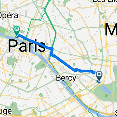
19/01/11 canal de l'ourcq + un bout de marne
A cycling route starting in Saint-Mandé, Île-de-France Region, France.
Overview
About this route
Starting from Nation, I followed a D to Pt des lilas and it’s not great, it’s just road in Paris. Then I joined the canal and there’s the bike path for dozens of km so that’s cool. However, it’s much uglier than the Marne, we pass by camps of gypsies and many factories, in short, the only interest is the bike path. Several times we cross forests and if you have a racing bike: forget it right away, with a city bike, it’s a bit better but not ideal (I got a flat under Gressy), with a mountain bike it should work, I think. Then I reach the Marne by going through Chelles and it’s nice to finish like that, it’s calm and beautiful. I return home via Vincennes.
- -:--
- Duration
- 63.9 km
- Distance
- 179 m
- Ascent
- 183 m
- Descent
- ---
- Avg. speed
- ---
- Max. altitude
Continue with Bikemap
Use, edit, or download this cycling route
You would like to ride 19/01/11 canal de l'ourcq + un bout de marne or customize it for your own trip? Here is what you can do with this Bikemap route:
Free features
- Save this route as favorite or in collections
- Copy & plan your own version of this route
- Sync your route with Garmin or Wahoo
Premium features
Free trial for 3 days, or one-time payment. More about Bikemap Premium.
- Navigate this route on iOS & Android
- Export a GPX / KML file of this route
- Create your custom printout (try it for free)
- Download this route for offline navigation
Discover more Premium features.
Get Bikemap PremiumFrom our community
Other popular routes starting in Saint-Mandé
- tour de paris
- Distance
- 33.2 km
- Ascent
- 224 m
- Descent
- 224 m
- Location
- Saint-Mandé, Île-de-France Region, France
- HemifrĂĄn till Grande Arche de la Defese
- Distance
- 14.4 km
- Ascent
- 152 m
- Descent
- 139 m
- Location
- Saint-Mandé, Île-de-France Region, France
- paris-londres
- Distance
- 393.3 km
- Ascent
- 661 m
- Descent
- 695 m
- Location
- Saint-Mandé, Île-de-France Region, France
- 200 vers les Hauts de France
- Distance
- 198.6 km
- Ascent
- 635 m
- Descent
- 634 m
- Location
- Saint-Mandé, Île-de-France Region, France
- Slow ride in Saint-Mandé
- Distance
- 18.7 km
- Ascent
- 40 m
- Descent
- 40 m
- Location
- Saint-Mandé, Île-de-France Region, France
- Paris - Provins
- Distance
- 105.1 km
- Ascent
- 429 m
- Descent
- 374 m
- Location
- Saint-Mandé, Île-de-France Region, France
- Cykeluthyraren - hem
- Distance
- 5.5 km
- Ascent
- 33 m
- Descent
- 43 m
- Location
- Saint-Mandé, Île-de-France Region, France
- Hemifrån till södra sidan park
- Distance
- 3.6 km
- Ascent
- 15 m
- Descent
- 38 m
- Location
- Saint-Mandé, Île-de-France Region, France
Open it in the app