

Die Wutach entlang ins Klettgautal
A cycling route starting in Lauchringen, Baden-Wurttemberg, Germany.
Overview
About this route
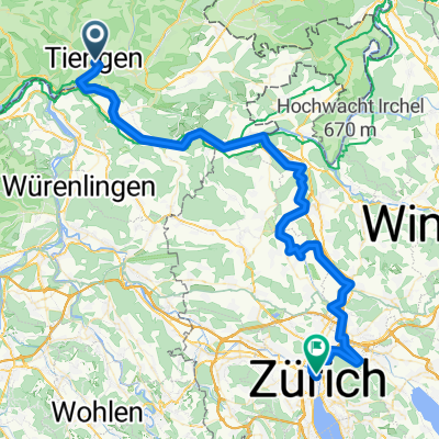
Start an der Eisenbahnbrücke in Lauchringen. Auf guten Radwegen dem Lauf der Wutach entgegen. In Stühlingen über die Grenze in die Schweiz. Hier zieht die Steigung kurz etwas an. Auf der Siblinger Höhe fantastische Aussicht in das Klettgautal und in den Schwarzwald. Schöne geschwungene Abfahrt nach Gächlingen. Weiter durch die Weinberge von Hallau wieder Richtung Deutschland zum Ausgangspunkt.
- -:--
- Duration
- 46.6 km
- Distance
- 286 m
- Ascent
- 258 m
- Descent
- ---
- Avg. speed
- 555 m
- Max. altitude
Route quality
Waytypes & surfaces along the route
Waytypes
Quiet road
13.6 km
(29 %)
Road
11.3 km
(24 %)
Surfaces
Paved
38.4 km
(83 %)
Unpaved
0.4 km
(<1 %)
Asphalt
37.5 km
(80 %)
Paved (undefined)
1 km
(2 %)
Continue with Bikemap
Use, edit, or download this cycling route
You would like to ride Die Wutach entlang ins Klettgautal or customize it for your own trip? Here is what you can do with this Bikemap route:
Free features
- Save this route as favorite or in collections
- Copy & plan your own version of this route
- Sync your route with Garmin or Wahoo
Premium features
Free trial for 3 days, or one-time payment. More about Bikemap Premium.
- Navigate this route on iOS & Android
- Export a GPX / KML file of this route
- Create your custom printout (try it for free)
- Download this route for offline navigation
Discover more Premium features.
Get Bikemap PremiumFrom our community
Other popular routes starting in Lauchringen
 Äulemer Kreuz - Lauchringen -Rundfahrt
- Distance
- 99.9 km
- Ascent
- 1,567 m
- Descent
- 1,497 m
- Location
- Lauchringen, Baden-Wurttemberg, Germany
 Entspannte Route
- Distance
- 31.6 km
- Ascent
- 113 m
- Descent
- 117 m
- Location
- Lauchringen, Baden-Wurttemberg, Germany
 Tiengen-Feldberg und zurück
- Distance
- 93.1 km
- Ascent
- 1,230 m
- Descent
- 1,234 m
- Location
- Lauchringen, Baden-Wurttemberg, Germany
 Abendrunde rund um Tiengen
- Distance
- 25.6 km
- Ascent
- 650 m
- Descent
- 650 m
- Location
- Lauchringen, Baden-Wurttemberg, Germany
 3-TagesTour 3 - Waldshut Küsnacht
- Distance
- 85.7 km
- Ascent
- 1,280 m
- Descent
- 1,176 m
- Location
- Lauchringen, Baden-Wurttemberg, Germany
 076b BIKETOUR - Herrmann Waldshut Zürich Final
- Distance
- 69.7 km
- Ascent
- 531 m
- Descent
- 459 m
- Location
- Lauchringen, Baden-Wurttemberg, Germany
 Die Wutach entlang ins Klettgautal
- Distance
- 46.6 km
- Ascent
- 286 m
- Descent
- 258 m
- Location
- Lauchringen, Baden-Wurttemberg, Germany
 Ausfahrt durch Küssaberg
- Distance
- 19.7 km
- Ascent
- 546 m
- Descent
- 545 m
- Location
- Lauchringen, Baden-Wurttemberg, Germany
Open it in the app