

ruta el núcleo duro
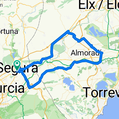
A cycling route starting in Santomera, Murcia, Spain.
Overview
About this route
Partially it is not a hard route, although it is not recommended for very inexperienced people in MTB. Most of the route goes along forest paths, although we will have several stony trails and too many trenches due to the rain. We leave from the forest house towards the 'municipal buttock place' and will skirt the Rambla del Agua for a stretch. We will take the path that leads us to Casia Cagarrias, although we will not arrive there yet as we will divert through a trail. After a somewhat hard ascent for the legs through a very stony path, we reach the descent of El Calvario. We will reach Casa Cagarrias and climb up to the ponds, and via a very wide and well-maintained path we will reach the national road. We will cross the National (Truck passage caution) and will start a kind of roller coaster skirting the Santomera swamp. Be careful in some areas as there are some complicated trenches if it is your first time passing through there. We will pass the dam, and right after that we will start the ascent to La Antena, a prolonged climb and a bit hard due to the state of the road but not due to the incline, and once crowned we will have a short but fun descent (pay attention to the first section). And finally, we will set course for the forest house.
- -:--
- Duration
- 27.2 km
- Distance
- 383 m
- Ascent
- 382 m
- Descent
- ---
- Avg. speed
- ---
- Max. altitude
Route quality
Waytypes & surfaces along the route
Waytypes
Track
16 km
(59 %)
Path
7.3 km
(27 %)
Surfaces
Paved
1.1 km
(4 %)
Unpaved
9.2 km
(34 %)
Ground
9.2 km
(34 %)
Asphalt
1.1 km
(4 %)
Undefined
16.8 km
(62 %)
Route highlights
Points of interest along the route
Point of interest after 0.9 km
zona de enculado. Si no eres gay ir bien sentadito
Point of interest after 25 km
bajo el puente de la nacional
Continue with Bikemap
Use, edit, or download this cycling route
You would like to ride ruta el núcleo duro or customize it for your own trip? Here is what you can do with this Bikemap route:
Free features
- Save this route as favorite or in collections
- Copy & plan your own version of this route
- Sync your route with Garmin or Wahoo
Premium features
Free trial for 3 days, or one-time payment. More about Bikemap Premium.
- Navigate this route on iOS & Android
- Export a GPX / KML file of this route
- Create your custom printout (try it for free)
- Download this route for offline navigation
Discover more Premium features.
Get Bikemap PremiumFrom our community
Other popular routes starting in Santomera
 De Santomera a Pilar Horadad por Altahona, Gravel
- Distance
- 55.4 km
- Ascent
- 551 m
- Descent
- 554 m
- Location
- Santomera, Murcia, Spain
 Etapa 1-marzo
- Distance
- 111.9 km
- Ascent
- 1,104 m
- Descent
- 1,103 m
- Location
- Santomera, Murcia, Spain
 Etapa 2-marzo
- Distance
- 104.8 km
- Ascent
- 784 m
- Descent
- 784 m
- Location
- Santomera, Murcia, Spain
 Etapa 2-mayo
- Distance
- 101 km
- Ascent
- 1,272 m
- Descent
- 1,272 m
- Location
- Santomera, Murcia, Spain
 Cobatillas_Alcayna_Ojos_Fenazar_Fortuna_EnbalseSantomera
- Distance
- 96.2 km
- Ascent
- 1,145 m
- Descent
- 1,142 m
- Location
- Santomera, Murcia, Spain
 Etapa 2-febrero
- Distance
- 95.2 km
- Ascent
- 599 m
- Descent
- 600 m
- Location
- Santomera, Murcia, Spain
 Etapa 5-marzo
- Distance
- 95.5 km
- Ascent
- 599 m
- Descent
- 600 m
- Location
- Santomera, Murcia, Spain
 Etapa -jueves santo
- Distance
- 89.3 km
- Ascent
- 176 m
- Descent
- 176 m
- Location
- Santomera, Murcia, Spain
Open it in the app