

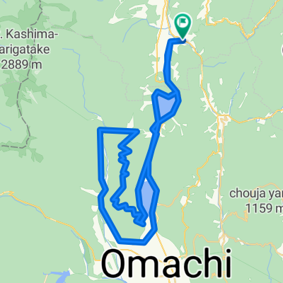
Hakuba's Best Scenic Spots Route
A cycling route starting in Hakuba, Nagano, Japan.
Overview
About this route
This is best cycling route in Hakuba. Please enojoy cycling !
- -:--
- Duration
- 27.3 km
- Distance
- 314 m
- Ascent
- 315 m
- Descent
- ---
- Avg. speed
- ---
- Avg. speed

Continue with Bikemap
Use, edit, or download this cycling route
You would like to ride Hakuba's Best Scenic Spots Route or customize it for your own trip? Here is what you can do with this Bikemap route:
Free features
- Save this route as favorite or in collections
- Copy & plan your own version of this route
- Sync your route with Garmin or Wahoo
Premium features
Free trial for 3 days, or one-time payment. More about Bikemap Premium.
- Navigate this route on iOS & Android
- Export a GPX / KML file of this route
- Create your custom printout (try it for free)
- Download this route for offline navigation
Discover more Premium features.
Get Bikemap PremiumFrom our community
Other popular routes starting in Hakuba
 Rural Scene Along the Hime River
- Distance
- 12.1 km
- Ascent
- 122 m
- Descent
- 123 m
- Location
- Hakuba, Nagano, Japan
 Nishina three lakes and Mt.Koguma Hill Climb
- Distance
- 57.1 km
- Ascent
- 1,294 m
- Descent
- 1,299 m
- Location
- Hakuba, Nagano, Japan
 Superb View Cycling Route
- Distance
- 68.5 km
- Ascent
- 1,959 m
- Descent
- 1,957 m
- Location
- Hakuba, Nagano, Japan
 白馬駅コース
- Distance
- 10.1 km
- Ascent
- 90 m
- Descent
- 88 m
- Location
- Hakuba, Nagano, Japan
 Village Forest and Nishina three lakes
- Distance
- 40 km
- Ascent
- 858 m
- Descent
- 860 m
- Location
- Hakuba, Nagano, Japan
 Hakuba's Best Scenic Spots Route
- Distance
- 27.3 km
- Ascent
- 314 m
- Descent
- 315 m
- Location
- Hakuba, Nagano, Japan
 Scenic Short Cycling Route
- Distance
- 8.8 km
- Ascent
- 109 m
- Descent
- 107 m
- Location
- Hakuba, Nagano, Japan
 09-10-2013_Day07
- Distance
- 109.6 km
- Ascent
- 1,084 m
- Descent
- 1,754 m
- Location
- Hakuba, Nagano, Japan
Open it in the app