

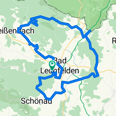
Traberg-CZ-Sternrunde
A cycling route starting in Bad Leonfelden, Upper Austria, Austria.
Overview
About this route
Traberg, Guglwald, Kapellen, Dürnau, Sternstein, Vorderweißenbach, Bernhardschlag - Traberg
- -:--
- Duration
- 45.1 km
- Distance
- 791 m
- Ascent
- 793 m
- Descent
- ---
- Avg. speed
- ---
- Max. altitude

Route quality
Waytypes & surfaces along the route
Waytypes
Quiet road
20.3 km
(45 %)
Road
13.1 km
(29 %)
Surfaces
Paved
23.9 km
(53 %)
Unpaved
6.8 km
(15 %)
Asphalt
23.9 km
(53 %)
Gravel
3.6 km
(8 %)
Continue with Bikemap
Use, edit, or download this cycling route
You would like to ride Traberg-CZ-Sternrunde or customize it for your own trip? Here is what you can do with this Bikemap route:
Free features
- Save this route as favorite or in collections
- Copy & plan your own version of this route
- Sync your route with Garmin or Wahoo
Premium features
Free trial for 3 days, or one-time payment. More about Bikemap Premium.
- Navigate this route on iOS & Android
- Export a GPX / KML file of this route
- Create your custom printout (try it for free)
- Download this route for offline navigation
Discover more Premium features.
Get Bikemap PremiumFrom our community
Other popular routes starting in Bad Leonfelden
 Radrunde von Bad Leonfelden nach Linz
- Distance
- 32.9 km
- Ascent
- 291 m
- Descent
- 781 m
- Location
- Bad Leonfelden, Upper Austria, Austria
 Grosstraberg CZ, neuer Radweg Vyssi Brod
- Distance
- 62 km
- Ascent
- 910 m
- Descent
- 932 m
- Location
- Bad Leonfelden, Upper Austria, Austria
 Schwedenschanze+Sternsteinrunde
- Distance
- 39.1 km
- Ascent
- 485 m
- Descent
- 633 m
- Location
- Bad Leonfelden, Upper Austria, Austria
 Traberg - Sternsteinwarte - Abfahrt Schipiste - Traberg
- Distance
- 28.4 km
- Ascent
- 765 m
- Descent
- 796 m
- Location
- Bad Leonfelden, Upper Austria, Austria
 BL-NWkammweg-summerau-mühlenweg-BL
- Distance
- 39.4 km
- Ascent
- 664 m
- Descent
- 665 m
- Location
- Bad Leonfelden, Upper Austria, Austria
 Traberg - Sternsteinwarte - Traberg
- Distance
- 29.8 km
- Ascent
- 879 m
- Descent
- 921 m
- Location
- Bad Leonfelden, Upper Austria, Austria
 Traberg-CZ-Sternrunde
- Distance
- 45.1 km
- Ascent
- 791 m
- Descent
- 793 m
- Location
- Bad Leonfelden, Upper Austria, Austria
 Unterstifting Kurhausstraße 7, Burgfried
- Distance
- 18 km
- Ascent
- 359 m
- Descent
- 319 m
- Location
- Bad Leonfelden, Upper Austria, Austria
Open it in the app