

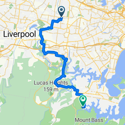
Regents Park to KCCS Arncliffe via Cooks River Cycleway
A cycling route starting in Regents Park, New South Wales, Australia.
Overview
About this route
The sections between the cycleways have some steep hills. Most of the trip is off roads. The busiest streets are Amy Street, Regents Park up to Weeroona Road roundabout and along Wardell Road. There are steep climbs through Earlwood along Riverview, Bass, Nelson and Waitkin Roads. You need to cross at the lights at Homer Street. There is a steep descent down Banks/ Finlays Roads Earlwood to the Turella track. It is all uphill for that last 1.5 km to KCCS.
- -:--
- Duration
- 18.4 km
- Distance
- 102 m
- Ascent
- 113 m
- Descent
- ---
- Avg. speed
- ---
- Max. altitude

Route quality
Waytypes & surfaces along the route
Waytypes
Cycleway
9.4 km
(51 %)
Quiet road
6.8 km
(37 %)
Surfaces
Paved
17.5 km
(95 %)
Concrete
8.5 km
(46 %)
Asphalt
5.9 km
(32 %)
Continue with Bikemap
Use, edit, or download this cycling route
You would like to ride Regents Park to KCCS Arncliffe via Cooks River Cycleway or customize it for your own trip? Here is what you can do with this Bikemap route:
Free features
- Save this route as favorite or in collections
- Copy & plan your own version of this route
- Sync your route with Garmin or Wahoo
Premium features
Free trial for 3 days, or one-time payment. More about Bikemap Premium.
- Navigate this route on iOS & Android
- Export a GPX / KML file of this route
- Create your custom printout (try it for free)
- Download this route for offline navigation
Discover more Premium features.
Get Bikemap PremiumFrom our community
Other popular routes starting in Regents Park
 Magney Ave, Regents Park to Grays Point Rd, Royal National Park
- Distance
- 40 km
- Ascent
- 482 m
- Descent
- 436 m
- Location
- Regents Park, New South Wales, Australia
 66 Wyatt Avenue, Regents Park to 19 Dowling Street, Arncliffe
- Distance
- 19.6 km
- Ascent
- 59 m
- Descent
- 95 m
- Location
- Regents Park, New South Wales, Australia
 66 Wyatt Avenue, Regents Park to 18 Woodlands Avenue, Breakfast Point
- Distance
- 6,050.5 km
- Ascent
- 113 m
- Descent
- 152 m
- Location
- Regents Park, New South Wales, Australia
 Dunc Gray Velodrome to Silverwater Bridge
- Distance
- 22.1 km
- Ascent
- 77 m
- Descent
- 115 m
- Location
- Regents Park, New South Wales, Australia
 1 Johnston Rd, Bass Hill to 83 Milperra Rd, Revesby
- Distance
- 5.7 km
- Ascent
- 37 m
- Descent
- 61 m
- Location
- Regents Park, New South Wales, Australia
 9 Patricia St, Chester Hill to 9 Patricia St, Chester Hill
- Distance
- 4.1 km
- Ascent
- 27 m
- Descent
- 22 m
- Location
- Regents Park, New South Wales, Australia
 Dunc Gray to Elizabeth Drv via HLD M5 M7
- Distance
- 28.1 km
- Ascent
- 224 m
- Descent
- 137 m
- Location
- Regents Park, New South Wales, Australia
 Dunc Gray Velodrome to Randwick Plaza
- Distance
- 31.8 km
- Ascent
- 193 m
- Descent
- 161 m
- Location
- Regents Park, New South Wales, Australia
Open it in the app