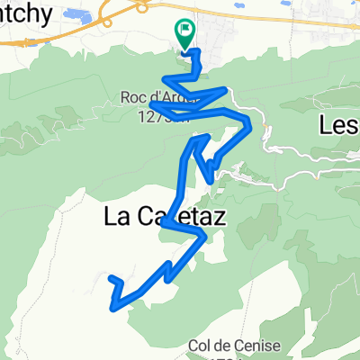
col les fleuries
A cycling route starting in Ayse, Auvergne-Rh么ne-Alpes, France.
Overview
About this route
- -:--
- Duration
- 56.1 km
- Distance
- 690 m
- Ascent
- 688 m
- Descent
- ---
- Avg. speed
- ---
- Avg. speed
Route quality
Waytypes & surfaces along the route
Waytypes
Road
38.9 km
(69 %)
Quiet road
13.3 km
(24 %)
Surfaces
Paved
22.4 km
(40 %)
Unpaved
0.3 km
(<1 %)
Asphalt
22.1 km
(39 %)
Paved (undefined)
0.4 km
(<1 %)
Continue with Bikemap
Use, edit, or download this cycling route
You would like to ride col les fleuries or customize it for your own trip? Here is what you can do with this Bikemap route:
Free features
- Save this route as favorite or in collections
- Copy & plan your own version of this route
- Sync your route with Garmin or Wahoo
Premium features
Free trial for 3 days, or one-time payment. More about Bikemap Premium.
- Navigate this route on iOS & Android
- Export a GPX / KML file of this route
- Create your custom printout (try it for free)
- Download this route for offline navigation
Discover more Premium features.
Get Bikemap PremiumFrom our community
Other popular routes starting in Ayse
- col les fleuries
- Distance
- 56.1 km
- Ascent
- 690 m
- Descent
- 688 m
- Location
- Ayse, Auvergne-Rh么ne-Alpes, France
- Ue, duex trois... Solaison!
- Distance
- 54 km
- Ascent
- 2,130 m
- Descent
- 1,074 m
- Location
- Ayse, Auvergne-Rh么ne-Alpes, France
- Grand Bernard
- Distance
- 58.5 km
- Ascent
- 1,165 m
- Descent
- 1,169 m
- Location
- Ayse, Auvergne-Rh么ne-Alpes, France
- Glieres Raid
- Distance
- 106.5 km
- Ascent
- 2,801 m
- Descent
- 2,803 m
- Location
- Ayse, Auvergne-Rh么ne-Alpes, France
- col du perret rour du m么le
- Distance
- 60 km
- Ascent
- 721 m
- Descent
- 722 m
- Location
- Ayse, Auvergne-Rh么ne-Alpes, France
- Col de Solaison
- Distance
- 24.1 km
- Ascent
- 1,045 m
- Descent
- 1,045 m
- Location
- Ayse, Auvergne-Rh么ne-Alpes, France
- L_etape_du tour_Ayse-Marignier-LaRamaz-JouxPlaines_Morzine_LeGets_Ayse
- Distance
- 111.2 km
- Ascent
- 2,431 m
- Descent
- 2,441 m
- Location
- Ayse, Auvergne-Rh么ne-Alpes, France
- Annecy #1
- Distance
- 141.5 km
- Ascent
- 3,341 m
- Descent
- 3,341 m
- Location
- Ayse, Auvergne-Rh么ne-Alpes, France
Open it in the app