Joseph-Fraunhofer-Straße 63, Pfaffenhofen an der Ilm nach Pfaffenhofen an der Ilm
A cycling route starting in Pfaffenhofen an der Ilm, Bavaria, Germany.
Overview
About this route
- 1 h 11 min
- Duration
- 19.3 km
- Distance
- 97 m
- Ascent
- 94 m
- Descent
- 16.4 km/h
- Avg. speed
- ---
- Max. altitude
Route photos
Route quality
Waytypes & surfaces along the route
Waytypes
Quiet road
10.2 km
(53 %)
Path
3.5 km
(18 %)
Surfaces
Paved
15 km
(78 %)
Unpaved
0.6 km
(3 %)
Asphalt
15 km
(78 %)
Loose gravel
0.6 km
(3 %)
Undefined
3.7 km
(19 %)
Continue with Bikemap
Use, edit, or download this cycling route
You would like to ride Joseph-Fraunhofer-Straße 63, Pfaffenhofen an der Ilm nach Pfaffenhofen an der Ilm or customize it for your own trip? Here is what you can do with this Bikemap route:
Free features
- Save this route as favorite or in collections
- Copy & plan your own version of this route
- Sync your route with Garmin or Wahoo
Premium features
Free trial for 3 days, or one-time payment. More about Bikemap Premium.
- Navigate this route on iOS & Android
- Export a GPX / KML file of this route
- Create your custom printout (try it for free)
- Download this route for offline navigation
Discover more Premium features.
Get Bikemap PremiumFrom our community
Other popular routes starting in Pfaffenhofen an der Ilm
eQ - Förnbacher Forst - Arreshausen- Distance
- 16.5 km
- Ascent
- 270 m
- Descent
- 272 m
- Location
- Pfaffenhofen an der Ilm, Bavaria, Germany
Joseph-Fraunhofer-Straße 63, Pfaffenhofen an der Ilm nach Pfaffenhofen an der Ilm- Distance
- 19.3 km
- Ascent
- 97 m
- Descent
- 94 m
- Location
- Pfaffenhofen an der Ilm, Bavaria, Germany
PAF - Rothsee- Distance
- 109.8 km
- Ascent
- 330 m
- Descent
- 383 m
- Location
- Pfaffenhofen an der Ilm, Bavaria, Germany
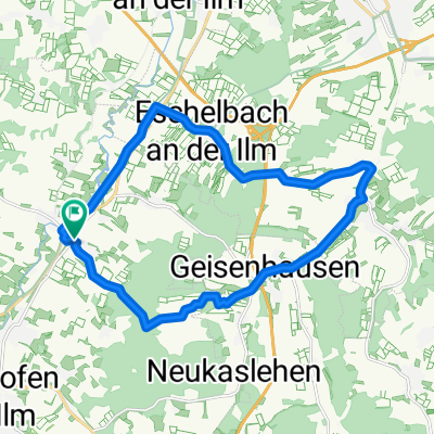
Feierabendrunde Sendeturm Wolfsberg- Distance
- 22.2 km
- Ascent
- 227 m
- Descent
- 226 m
- Location
- Pfaffenhofen an der Ilm, Bavaria, Germany
Römer - Tag 2- Distance
- 38.6 km
- Ascent
- 99 m
- Descent
- 146 m
- Location
- Pfaffenhofen an der Ilm, Bavaria, Germany
Panoramaweg Ost - PAF- Distance
- 21.1 km
- Ascent
- 134 m
- Descent
- 146 m
- Location
- Pfaffenhofen an der Ilm, Bavaria, Germany
Pfaffenhofen (Ilm)-Au i.d. Hallertau- Distance
- 66.7 km
- Ascent
- 725 m
- Descent
- 732 m
- Location
- Pfaffenhofen an der Ilm, Bavaria, Germany
Ho4a: Paffenhofen a.d. Ilm - Feilenmoos (Manching) 73,5km 315hm- Distance
- 73.5 km
- Ascent
- 315 m
- Descent
- 375 m
- Location
- Pfaffenhofen an der Ilm, Bavaria, Germany
Open it in the app

