

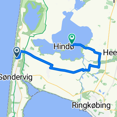
Fjord+
A cycling route starting in Ringkøbing, Central Jutland, Denmark.
Overview
About this route
- 1 h 51 min
- Duration
- 25.7 km
- Distance
- 43 m
- Ascent
- 34 m
- Descent
- 14 km/h
- Avg. speed
- ---
- Max. altitude

Route photos

Route quality
Waytypes & surfaces along the route
Waytypes
Path
7.6 km
(29 %)
Quiet road
7.5 km
(29 %)
Surfaces
Paved
11.3 km
(44 %)
Unpaved
3.2 km
(12 %)
Asphalt
11.3 km
(44 %)
Gravel
2.5 km
(10 %)
Continue with Bikemap
Use, edit, or download this cycling route
You would like to ride Fjord+ or customize it for your own trip? Here is what you can do with this Bikemap route:
Free features
- Save this route as favorite or in collections
- Copy & plan your own version of this route
- Sync your route with Garmin or Wahoo
Premium features
Free trial for 3 days, or one-time payment. More about Bikemap Premium.
- Navigate this route on iOS & Android
- Export a GPX / KML file of this route
- Create your custom printout (try it for free)
- Download this route for offline navigation
Discover more Premium features.
Get Bikemap PremiumFrom our community
Other popular routes starting in Ringkøbing
 NSCR Danmark 2
- Distance
- 610.5 km
- Ascent
- 713 m
- Descent
- 713 m
- Location
- Ringkøbing, Central Jutland, Denmark
 Lengthy ride through Lodbjerg Hede
- Distance
- 41.7 km
- Ascent
- 21 m
- Descent
- 20 m
- Location
- Ringkøbing, Central Jutland, Denmark
 Ternedalen, Ringkøbing nach Hee, Ringkøbing
- Distance
- 17.1 km
- Ascent
- 21 m
- Descent
- 25 m
- Location
- Ringkøbing, Central Jutland, Denmark
 Rundfahrt Ringköbing-Fjord
- Distance
- 96 km
- Ascent
- 259 m
- Descent
- 265 m
- Location
- Ringkøbing, Central Jutland, Denmark
 les avions à vélo: Day 11
- Distance
- 148.4 km
- Ascent
- 624 m
- Descent
- 588 m
- Location
- Ringkøbing, Central Jutland, Denmark
 Ternedalen, Ringkøbing nach Havnepladsen, Ringkøbing
- Distance
- 12.2 km
- Ascent
- 3 m
- Descent
- 6 m
- Location
- Ringkøbing, Central Jutland, Denmark
 Vellingvej, Ringkøbing nach Ternedalen, Ringkøbing
- Distance
- 20.5 km
- Ascent
- 129 m
- Descent
- 128 m
- Location
- Ringkøbing, Central Jutland, Denmark
 Ternedalen, Ringkøbing nach Parallelvej, Hvide Sande
- Distance
- 18.3 km
- Ascent
- 187 m
- Descent
- 189 m
- Location
- Ringkøbing, Central Jutland, Denmark
Open it in the app