

Rymanów - Miejsce Piastowe - Dukla - Daliowa (pętla)
A cycling route starting in Rymanów, Subcarpathian Voivodeship, Poland.
Overview
About this route
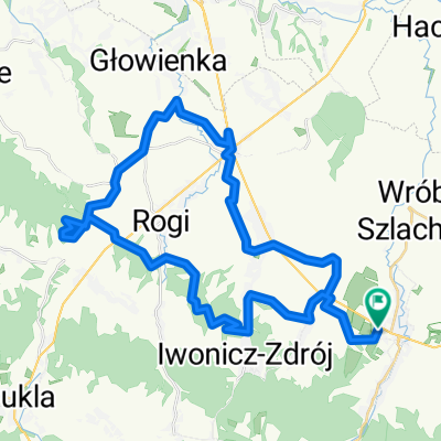
For me personally, this route should be classified among mountain routes, even though part of it is on flat terrain. We start at the market square in Rymanów with a downhill from a hill. Then we move on flat terrain towards the roundabout in Miejsce Piastowe. There is also an alternative for this route: passing through Iwonicz to Rogi. Once we have arrived in Rogi by one of these ways, a journey towards the Slovak border awaits us. Right at the very beginning, on the dual carriageway, we encounter a big obstacle. An exhausting climb awaits us, followed by a crazy descent where professionals reached speeds of up to 100 km/h! Next, we head to Dukla, where we find, among other things, the Historical Museum and the late Baroque church dedicated to St. Mary Magdalene. In the Dukla municipality, there is also the famous Valley of Death, but we will only touch its borders. These areas have a very rich history, but here I should only speak about the cycling aspects. So we passed through Dukla and continue towards the Slovak border. We pass through more towns until we reach Trzciana. Here I would also like to stop, as it is a special place for me. Whenever I can, I visit the Hermitage of St. John of Dukla. It is worth stopping here especially for sporting reasons. A terribly hard climb, which many cyclists have cursed in their minds (despite the recognition of these places as sacred), must be overcome to reach the source of "janowa" water. Nevertheless, I always pull myself together and climb up. I definitely consider this climb the hardest I have ever done (probably the gradient exceeds 10%). After a short rest, we continue and after a few kilometres we turn east, leaving the border on the right side. On the way to Daliowa, we pass a campsite, an 8-percent incline, and the small village of Stasiany. After these small adventures, in Daliowa we turn left. These roads are not busy with cars, so you can maintain only an average level of caution. However, beware of motorcyclists; they like to race on these mountainous terrains. After turning, we find ourselves on a road leading directly to Rymanów. Just before and after Szklarz, there are some medium-difficulty climbs, which are not very well represented on the elevation profile. Then a technically difficult descent with hairpin bends awaits us. You can only reach about 40 km/h there, as the turns are very tight and we only have one lane. Then, until Rymanów-Zdrój, a descent awaits us, i.e., continuous downhills. It is worth sightseeing during this time. A valuable monument is the ruins of a small church located just before Królik Polski. The "Celestynka" water bottling plant is also interesting (yes, secret advertising). Only in Posada Górna does the terrain start to worsen, i.e., rise. We finish the ride at the same square where we started. Thank you for getting acquainted with my route and I wish you a pleasant journey, Denzelon.
- -:--
- Duration
- 54.6 km
- Distance
- 465 m
- Ascent
- 465 m
- Descent
- ---
- Avg. speed
- ---
- Max. altitude

Continue with Bikemap
Use, edit, or download this cycling route
You would like to ride Rymanów - Miejsce Piastowe - Dukla - Daliowa (pętla) or customize it for your own trip? Here is what you can do with this Bikemap route:
Free features
- Save this route as favorite or in collections
- Copy & plan your own version of this route
- Sync your route with Garmin or Wahoo
Premium features
Free trial for 3 days, or one-time payment. More about Bikemap Premium.
- Navigate this route on iOS & Android
- Export a GPX / KML file of this route
- Create your custom printout (try it for free)
- Download this route for offline navigation
Discover more Premium features.
Get Bikemap PremiumFrom our community
Other popular routes starting in Rymanów
 20220902
- Distance
- 88 km
- Ascent
- 833 m
- Descent
- 833 m
- Location
- Rymanów, Subcarpathian Voivodeship, Poland
 zródła jasiołki, polany surowiczne, przymiarki
- Distance
- 83.5 km
- Ascent
- 1,459 m
- Descent
- 1,450 m
- Location
- Rymanów, Subcarpathian Voivodeship, Poland
 Rymanów-kalwaria-mogiła-sucha góra-klimkówka-łysa góra-pustki-rymanów
- Distance
- 18.5 km
- Ascent
- 583 m
- Descent
- 581 m
- Location
- Rymanów, Subcarpathian Voivodeship, Poland
 Rymanów - Pustki - Klimkówa - wiatraki - Iwonicz - Miejsce Piastowe - Wrocanka - Niżna Łąka - Równe - Wietrzno - Równe - Rogi - Iwonicz - Klimkówka - Pustki - R
- Distance
- 43 km
- Ascent
- 539 m
- Descent
- 539 m
- Location
- Rymanów, Subcarpathian Voivodeship, Poland
 Rymanów - Trześmiów - Długie
- Distance
- 25.3 km
- Ascent
- 101 m
- Descent
- 134 m
- Location
- Rymanów, Subcarpathian Voivodeship, Poland
 Beskid Niski Łemkowszczyzna
- Distance
- 110.5 km
- Ascent
- 0 m
- Descent
- 0 m
- Location
- Rymanów, Subcarpathian Voivodeship, Poland
 Rymanów - Miejsce Piastowe - Dukla - Daliowa (pętla)
- Distance
- 54.6 km
- Ascent
- 465 m
- Descent
- 465 m
- Location
- Rymanów, Subcarpathian Voivodeship, Poland
 Zdrojowa 57, Rymanów-Zdrój do Zdrojowa 57, Rymanów-Zdrój
- Distance
- 51 km
- Ascent
- 774 m
- Descent
- 774 m
- Location
- Rymanów, Subcarpathian Voivodeship, Poland
Open it in the app