
# 3 GSR "EDU 9"
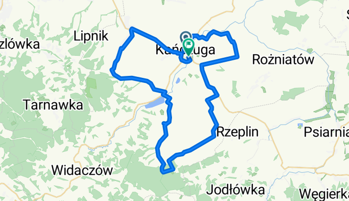
A cycling route starting in Kańczuga, Subcarpathian Voivodeship, Poland.
Overview
About this route
Gminny Szlak Rowerowy „EDU 9”.
Długość: 43,5 km / 98% asfalt - pozostałe 2% to ok.1km leśna,gruntowa droga Rączyna Łopuszka Wlk ( na 20,5 -21,5 km szlaku) . W zasadzie trasa przeznaczona dla wszystkich typów rowerów, z zastrzeżeniem , że wymieniony 1 km leśny odcinek dla rowerów szosowych przejezdny gdy sucho, ewentualnie spacerek w pięknych okolicznościach przyrody. Na terenia Gminy Kańczuga zlokalizowane jest 7 Szkół Podstawowych + 1 Szkoła średnia + Szkoła Muzyczna = EDU 9 3 szkoły w mieście Kańczuga pozostałe 6 na terenie największych wiosek w gminie.
Start : -Szkoła Podstawowa im.Jana III Sobieskiego w Kańczudze/ Szkoła Muzyczna I stopnia (0km) Szkoły : -SP Krzeczowice (6km) - SP Pantalowice (13km) - SP Rączyna (17 km) - SP Łopuszka Wlk. (26 km) - SP Siedleczka (30 km) - SP Sietesz (36 km) Koniec Szlaku -Meta (43,5 km) Zespół Szkół / Hala sportowa.
- -:--
- Duration
- 43.2 km
- Distance
- 380 m
- Ascent
- 388 m
- Descent
- ---
- Avg. speed
- 386 m
- Max. altitude

Route quality
Waytypes & surfaces along the route
Waytypes
Quiet road
21.2 km
(49 %)
Road
12.1 km
(28 %)
Surfaces
Paved
30.7 km
(71 %)
Asphalt
30.7 km
(71 %)
Undefined
12.5 km
(29 %)
Route highlights
Points of interest along the route
Point of interest after 0 km
SS (Start Szlaku) Kańczuga 0 km
Point of interest after 21.8 km
MOR Łopuszka Wielka 22 km
Point of interest after 29.5 km
MOR Siedleczka 30 km
Point of interest after 43.2 km
KS (Koniec Szlaku) Kańczuga 43 km
Continue with Bikemap
Use, edit, or download this cycling route
You would like to ride # 3 GSR "EDU 9" or customize it for your own trip? Here is what you can do with this Bikemap route:
Free features
- Save this route as favorite or in collections
- Copy & plan your own version of this route
- Sync your route with Garmin or Wahoo
Premium features
Free trial for 3 days, or one-time payment. More about Bikemap Premium.
- Navigate this route on iOS & Android
- Export a GPX / KML file of this route
- Create your custom printout (try it for free)
- Download this route for offline navigation
Discover more Premium features.
Get Bikemap PremiumFrom our community
Other popular routes starting in Kańczuga
 75 (19/16) Rożniatów-Jarosław-WÓLKA PEŁKIŃSKA-Tryńcza-Przeworsk
- Distance
- 74.2 km
- Ascent
- 271 m
- Descent
- 271 m
- Location
- Kańczuga, Subcarpathian Voivodeship, Poland
 #2 GSR "Junior"
- Distance
- 17.3 km
- Ascent
- 145 m
- Descent
- 137 m
- Location
- Kańczuga, Subcarpathian Voivodeship, Poland
 # 3 GSR "EDU 9"
- Distance
- 43.2 km
- Ascent
- 380 m
- Descent
- 388 m
- Location
- Kańczuga, Subcarpathian Voivodeship, Poland
 65 (64/16) Przeworsk-Tryńcza-Pełkinie-Krzeczowice
- Distance
- 64.6 km
- Ascent
- 134 m
- Descent
- 134 m
- Location
- Kańczuga, Subcarpathian Voivodeship, Poland
 113/SIENIAWA-KURYŁÓWKA-ŁAŃCUT
- Distance
- 113.4 km
- Ascent
- 261 m
- Descent
- 261 m
- Location
- Kańczuga, Subcarpathian Voivodeship, Poland
 000(KRA) "Walnijmy setkę" (Koło Rowerowe Axtone) Propozycja 1
- Distance
- 96.1 km
- Ascent
- 556 m
- Descent
- 564 m
- Location
- Kańczuga, Subcarpathian Voivodeship, Poland
 Kańczuga Łopuszka Manasterz SIetesz. Podparpackie pogórze
- Distance
- 38.8 km
- Ascent
- 470 m
- Descent
- 470 m
- Location
- Kańczuga, Subcarpathian Voivodeship, Poland
 Trasa od bajeczna, kańczuga do bajeczna, kańczuga
- Distance
- 100.1 km
- Ascent
- 563 m
- Descent
- 563 m
- Location
- Kańczuga, Subcarpathian Voivodeship, Poland
Open it in the app