
Tag 6 Fernfahrt Bisamberg-Telfs (Finogogo & ZeroBiker1964
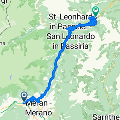
A cycling route starting in Algund, Trentino-Alto Adige, Italy.
Overview
About this route
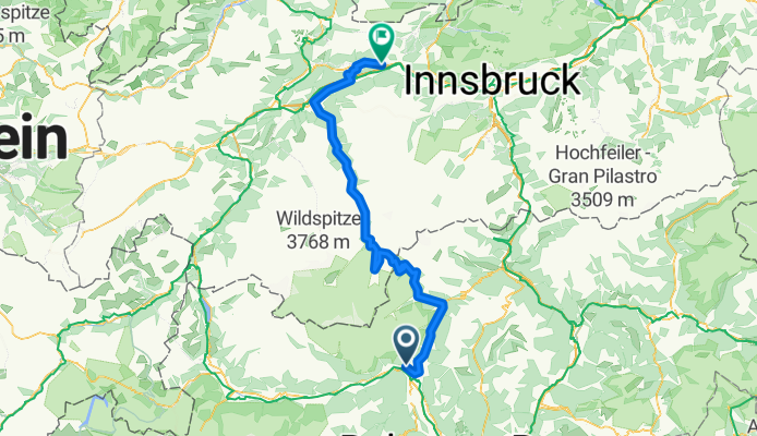
Algund - St. Leonhard i.P. - Moos i.P. - Timmelsjoch - Ötztal - Telfs
cool tour:
magnificent mountains, sunny heights
- -:--
- Duration
- 133.7 km
- Distance
- 2,392 m
- Ascent
- 2,025 m
- Descent
- ---
- Avg. speed
- ---
- Max. altitude
Route quality
Waytypes & surfaces along the route
Waytypes
Quiet road
20 km
(15 %)
Track
5.3 km
(4 %)
Surfaces
Paved
127 km
(95 %)
Unpaved
2.7 km
(2 %)
Asphalt
125.6 km
(94 %)
Paved (undefined)
1.3 km
(1 %)
Continue with Bikemap
Use, edit, or download this cycling route
You would like to ride Tag 6 Fernfahrt Bisamberg-Telfs (Finogogo & ZeroBiker1964 or customize it for your own trip? Here is what you can do with this Bikemap route:
Free features
- Save this route as favorite or in collections
- Copy & plan your own version of this route
- Split it into stages to create a multi-day tour
- Sync your route with Garmin or Wahoo
Premium features
Free trial for 3 days, or one-time payment. More about Bikemap Premium.
- Navigate this route on iOS & Android
- Export a GPX / KML file of this route
- Create your custom printout (try it for free)
- Download this route for offline navigation
Discover more Premium features.
Get Bikemap PremiumFrom our community
Other popular routes starting in Algund
 Allgund - Jaufenpass
- Distance
- 43 km
- Ascent
- 1,842 m
- Descent
- 146 m
- Location
- Algund, Trentino-Alto Adige, Italy
 Hotel Vigiljoch
- Distance
- 37 km
- Ascent
- 1,523 m
- Descent
- 1,510 m
- Location
- Algund, Trentino-Alto Adige, Italy
 Allgund - Schenna
- Distance
- 8.7 km
- Ascent
- 303 m
- Descent
- 48 m
- Location
- Algund, Trentino-Alto Adige, Italy
 Gasthof Brünnl
- Distance
- 9.5 km
- Ascent
- 434 m
- Descent
- 2 m
- Location
- Algund, Trentino-Alto Adige, Italy
 Bergtour über Gampenjoch und Meldelpass
- Distance
- 102.7 km
- Ascent
- 1,751 m
- Descent
- 1,751 m
- Location
- Algund, Trentino-Alto Adige, Italy
 Algund - Schloss Tirol - Muthöfe
- Distance
- 13.4 km
- Ascent
- 1,099 m
- Descent
- 127 m
- Location
- Algund, Trentino-Alto Adige, Italy
 Thalguter-1
- Distance
- 29.2 km
- Ascent
- 1,411 m
- Descent
- 82 m
- Location
- Algund, Trentino-Alto Adige, Italy
 Algund -Aschbach
- Distance
- 14.4 km
- Ascent
- 1,146 m
- Descent
- 122 m
- Location
- Algund, Trentino-Alto Adige, Italy
Open it in the app