

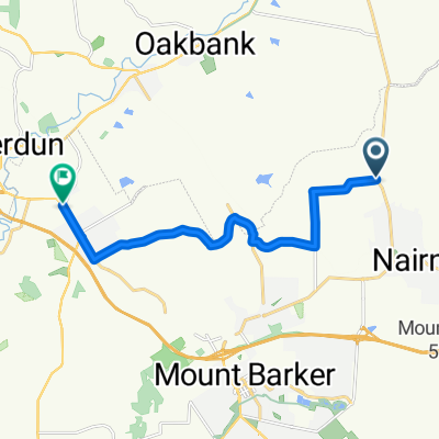
Nairne - Woodside - Balhannah - Ambleside Rd - Hahndorf
A cycling route starting in Nairne, South Australia, Australia.
Overview
About this route
- -:--
- Duration
- 22.8 km
- Distance
- 139 m
- Ascent
- 182 m
- Descent
- ---
- Avg. speed
- ---
- Max. altitude
Route quality
Waytypes & surfaces along the route
Waytypes
Quiet road
3 km
(13 %)
Road
2.3 km
(10 %)
Surfaces
Paved
21.4 km
(94 %)
Asphalt
15.3 km
(67 %)
Paved (undefined)
6.1 km
(27 %)
Undefined
1.4 km
(6 %)
Continue with Bikemap
Use, edit, or download this cycling route
You would like to ride Nairne - Woodside - Balhannah - Ambleside Rd - Hahndorf or customize it for your own trip? Here is what you can do with this Bikemap route:
Free features
- Save this route as favorite or in collections
- Copy & plan your own version of this route
- Sync your route with Garmin or Wahoo
Premium features
Free trial for 3 days, or one-time payment. More about Bikemap Premium.
- Navigate this route on iOS & Android
- Export a GPX / KML file of this route
- Create your custom printout (try it for free)
- Download this route for offline navigation
Discover more Premium features.
Get Bikemap PremiumFrom our community
Other popular routes starting in Nairne
 Nairne 89km Strath loop
- Distance
- 89.8 km
- Ascent
- 782 m
- Descent
- 782 m
- Location
- Nairne, South Australia, Australia
 Nairne 85km loop
- Distance
- 85 km
- Ascent
- 576 m
- Descent
- 574 m
- Location
- Nairne, South Australia, Australia
 Lot 100 to Ambleside
- Distance
- 12.4 km
- Ascent
- 153 m
- Descent
- 212 m
- Location
- Nairne, South Australia, Australia
 Nairne - Gumeracha - Mt. Torrens loop
- Distance
- 64.3 km
- Ascent
- 402 m
- Descent
- 402 m
- Location
- Nairne, South Australia, Australia
 Nairne loop
- Distance
- 65 km
- Ascent
- 521 m
- Descent
- 521 m
- Location
- Nairne, South Australia, Australia
 Mount Barker to Adelaide
- Distance
- 43.1 km
- Ascent
- 515 m
- Descent
- 844 m
- Location
- Nairne, South Australia, Australia
 Nairne - Mount Barker - Woodchester - Callington - Nairne
- Distance
- 63.8 km
- Ascent
- 494 m
- Descent
- 494 m
- Location
- Nairne, South Australia, Australia
 Nairne - Strath - Callington loop
- Distance
- 77.6 km
- Ascent
- 520 m
- Descent
- 520 m
- Location
- Nairne, South Australia, Australia
Open it in the app