

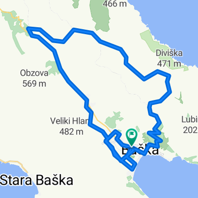
vrbnik-stara baška_02/2021
A cycling route starting in Punat, Primorje-Gorski Kotar County, Croatia.
Overview
About this route
- 5 h 37 min
- Duration
- 48.5 km
- Distance
- 745 m
- Ascent
- 739 m
- Descent
- 8.6 km/h
- Avg. speed
- 179 m
- Max. altitude

Route photos


Route quality
Waytypes & surfaces along the route
Waytypes
Busy road
27.5 km
(57 %)
Quiet road
11.2 km
(23 %)
Surfaces
Paved
43 km
(89 %)
Unpaved
0.8 km
(2 %)
Asphalt
41.1 km
(85 %)
Concrete
1.9 km
(4 %)
Continue with Bikemap
Use, edit, or download this cycling route
You would like to ride vrbnik-stara baška_02/2021 or customize it for your own trip? Here is what you can do with this Bikemap route:
Free features
- Save this route as favorite or in collections
- Copy & plan your own version of this route
- Sync your route with Garmin or Wahoo
Premium features
Free trial for 3 days, or one-time payment. More about Bikemap Premium.
- Navigate this route on iOS & Android
- Export a GPX / KML file of this route
- Create your custom printout (try it for free)
- Download this route for offline navigation
Discover more Premium features.
Get Bikemap PremiumFrom our community
Other popular routes starting in Punat
 Baška - Mjesec - Baška
- Distance
- 23.8 km
- Ascent
- 443 m
- Descent
- 443 m
- Location
- Punat, Primorje-Gorski Kotar County, Croatia
 Sheep's and views
- Distance
- 38.5 km
- Ascent
- 556 m
- Descent
- 571 m
- Location
- Punat, Primorje-Gorski Kotar County, Croatia
 MTB-Runde östlich von Baska
- Distance
- 33.3 km
- Ascent
- 528 m
- Descent
- 528 m
- Location
- Punat, Primorje-Gorski Kotar County, Croatia
 vrbnik-stara baška_02/2021
- Distance
- 48.5 km
- Ascent
- 745 m
- Descent
- 739 m
- Location
- Punat, Primorje-Gorski Kotar County, Croatia
 Krk-Stara Baska
- Distance
- 17.5 km
- Ascent
- 274 m
- Descent
- 318 m
- Location
- Punat, Primorje-Gorski Kotar County, Croatia
 vrbnik-sv.marek-garica-krk_02/2021
- Distance
- 44.6 km
- Ascent
- 645 m
- Descent
- 659 m
- Location
- Punat, Primorje-Gorski Kotar County, Croatia
 Baška-Vrbnik-Klimno-Malinska-Vrh-Malinska
- Distance
- 67.6 km
- Ascent
- 1,000 m
- Descent
- 998 m
- Location
- Punat, Primorje-Gorski Kotar County, Croatia
 vrbnik_dobrinj-poluotok_2018/10
- Distance
- 46.9 km
- Ascent
- 602 m
- Descent
- 636 m
- Location
- Punat, Primorje-Gorski Kotar County, Croatia
Open it in the app