
Ocotal
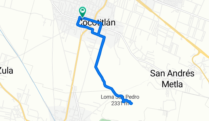
A cycling route starting in Cocotitlán, State of Mexico, Mexico.
Overview
About this route
- 54 min
- Duration
- 7.3 km
- Distance
- 118 m
- Ascent
- 95 m
- Descent
- 8.1 km/h
- Avg. speed
- ---
- Max. altitude

Continue with Bikemap
Use, edit, or download this cycling route
You would like to ride Ocotal or customize it for your own trip? Here is what you can do with this Bikemap route:
Free features
- Save this route as favorite or in collections
- Copy & plan your own version of this route
- Sync your route with Garmin or Wahoo
Premium features
Free trial for 3 days, or one-time payment. More about Bikemap Premium.
- Navigate this route on iOS & Android
- Export a GPX / KML file of this route
- Create your custom printout (try it for free)
- Download this route for offline navigation
Discover more Premium features.
Get Bikemap PremiumFrom our community
Other popular routes starting in Cocotitlán
 Paseo fácil
- Distance
- 18 km
- Ascent
- 134 m
- Descent
- 84 m
- Location
- Cocotitlán, State of Mexico, Mexico
 Ruta a Calle Galeana 39, Cocotitlán
- Distance
- 3.7 km
- Ascent
- 47 m
- Descent
- 7 m
- Location
- Cocotitlán, State of Mexico, Mexico
 Chamba 14
- Distance
- 38.5 km
- Ascent
- 156 m
- Descent
- 167 m
- Location
- Cocotitlán, State of Mexico, Mexico
 chamba 12
- Distance
- 38.5 km
- Ascent
- 198 m
- Descent
- 211 m
- Location
- Cocotitlán, State of Mexico, Mexico
 De 7523+97, San Gregorio Cuautzingo a Central de Abasto de la Ciudad de México
- Distance
- 38.1 km
- Ascent
- 168 m
- Descent
- 178 m
- Location
- Cocotitlán, State of Mexico, Mexico
 ccccc
ccccc- Distance
- 39.4 km
- Ascent
- 374 m
- Descent
- 374 m
- Location
- Cocotitlán, State of Mexico, Mexico
 chamba 10
- Distance
- 38.3 km
- Ascent
- 125 m
- Descent
- 141 m
- Location
- Cocotitlán, State of Mexico, Mexico
 chamba q2
- Distance
- 37.7 km
- Ascent
- 194 m
- Descent
- 220 m
- Location
- Cocotitlán, State of Mexico, Mexico
Open it in the app