

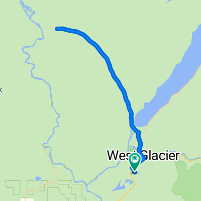
r238 ROAM
A cycling route starting in Columbia Falls, Montana, United States.
Overview
About this route
lion lake campgrounds-hungry horse reservoir-spotted bear campground-
- -:--
- Duration
- 90.5 km
- Distance
- 607 m
- Ascent
- 539 m
- Descent
- ---
- Avg. speed
- ---
- Max. altitude
Continue with Bikemap
Use, edit, or download this cycling route
You would like to ride r238 ROAM or customize it for your own trip? Here is what you can do with this Bikemap route:
Free features
- Save this route as favorite or in collections
- Copy & plan your own version of this route
- Split it into stages to create a multi-day tour
- Sync your route with Garmin or Wahoo
Premium features
Free trial for 3 days, or one-time payment. More about Bikemap Premium.
- Navigate this route on iOS & Android
- Export a GPX / KML file of this route
- Create your custom printout (try it for free)
- Download this route for offline navigation
Discover more Premium features.
Get Bikemap PremiumFrom our community
Other popular routes starting in Columbia Falls
 RMH Day 1
- Distance
- 96.7 km
- Ascent
- 1,331 m
- Descent
- 885 m
- Location
- Columbia Falls, Montana, United States
 Supersonic route in Columbia Falls
- Distance
- 40.3 km
- Ascent
- 310 m
- Descent
- 306 m
- Location
- Columbia Falls, Montana, United States
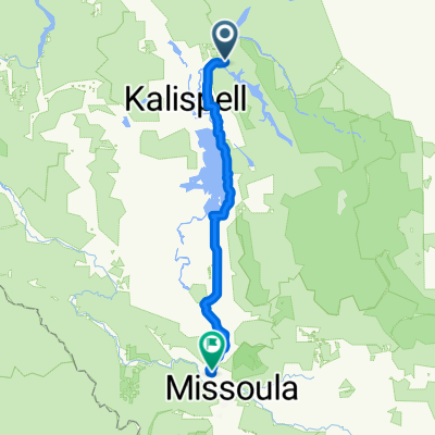 Glacier to Missoula
- Distance
- 203.3 km
- Ascent
- 992 m
- Descent
- 996 m
- Location
- Columbia Falls, Montana, United States
 Colombia Falls to Swan Lake
- Distance
- 69.9 km
- Ascent
- 272 m
- Descent
- 244 m
- Location
- Columbia Falls, Montana, United States
 U.S. 2 12070, West Glacier to U.S. 2 12070, West Glacier
- Distance
- 44.9 km
- Ascent
- 485 m
- Descent
- 488 m
- Location
- Columbia Falls, Montana, United States
 2013 GNP Day 1
- Distance
- 42.1 km
- Ascent
- 238 m
- Descent
- 170 m
- Location
- Columbia Falls, Montana, United States
 Recording from Feb 24, 2016, 1:20 PM
- Distance
- 0 km
- Ascent
- 0 m
- Descent
- 0 m
- Location
- Columbia Falls, Montana, United States
 Rocky Mountain High
- Distance
- 915.3 km
- Ascent
- 3,662 m
- Descent
- 3,580 m
- Location
- Columbia Falls, Montana, United States
Open it in the app