
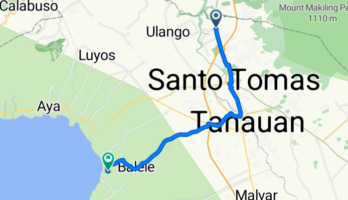
Pan-Philippine Highway 209, Santo Tomas to Unnamed Road, Tanauan
A cycling route starting in Pantay Na Matanda, Calabarzon, Philippines.
Overview
About this route
- 53 min
- Duration
- 15.9 km
- Distance
- 71 m
- Ascent
- 176 m
- Descent
- 18 km/h
- Avg. speed
- ---
- Max. altitude

Continue with Bikemap
Use, edit, or download this cycling route
You would like to ride Pan-Philippine Highway 209, Santo Tomas to Unnamed Road, Tanauan or customize it for your own trip? Here is what you can do with this Bikemap route:
Free features
- Save this route as favorite or in collections
- Copy & plan your own version of this route
- Sync your route with Garmin or Wahoo
Premium features
Free trial for 3 days, or one-time payment. More about Bikemap Premium.
- Navigate this route on iOS & Android
- Export a GPX / KML file of this route
- Create your custom printout (try it for free)
- Download this route for offline navigation
Discover more Premium features.
Get Bikemap PremiumFrom our community
Other popular routes starting in Pantay Na Matanda
 kaybiang reverse loop
- Distance
- 170.6 km
- Ascent
- 3,061 m
- Descent
- 3,059 m
- Location
- Pantay Na Matanda, Calabarzon, Philippines
 Lake Caliraya
- Distance
- 133.2 km
- Ascent
- 1,844 m
- Descent
- 1,844 m
- Location
- Pantay Na Matanda, Calabarzon, Philippines
 Unnamed Road, Santo Tomas to Wawa Road, Tanauan
- Distance
- 16.5 km
- Ascent
- 116 m
- Descent
- 244 m
- Location
- Pantay Na Matanda, Calabarzon, Philippines
 Laurel Mansion, Puting Lupa
- Distance
- 15.2 km
- Ascent
- 347 m
- Descent
- 336 m
- Location
- Pantay Na Matanda, Calabarzon, Philippines
 Unnamed Road, Calamba to Hipodromo 357, Maynila
- Distance
- 64.7 km
- Ascent
- 452 m
- Descent
- 583 m
- Location
- Pantay Na Matanda, Calabarzon, Philippines
 Pan-Philippine Highway 56, Calamba to Unnamed Road, Calamba
- Distance
- 3.8 km
- Ascent
- 290 m
- Descent
- 143 m
- Location
- Pantay Na Matanda, Calabarzon, Philippines
 dec 3 2021
- Distance
- 17.7 km
- Ascent
- 126 m
- Descent
- 124 m
- Location
- Pantay Na Matanda, Calabarzon, Philippines
 Pan-Philippine Highway 209, Santo Tomas to Unnamed Road, Tanauan
- Distance
- 15.9 km
- Ascent
- 71 m
- Descent
- 176 m
- Location
- Pantay Na Matanda, Calabarzon, Philippines
Open it in the app