

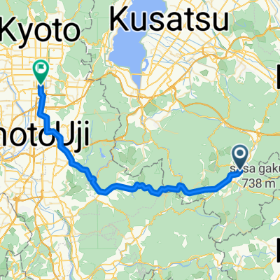
甲賀コース(忍びの里サイクリングコース)
A cycling route starting in Minakuchichō-matoba, Shiga Prefecture, Japan.
Overview
About this route
日本遺産忍びの里伊賀・甲賀を巡るサイクリングコース
- -:--
- Duration
- 37 km
- Distance
- 169 m
- Ascent
- 169 m
- Descent
- ---
- Avg. speed
- ---
- Max. altitude

Route quality
Waytypes & surfaces along the route
Waytypes
Quiet road
17 km
(46 %)
Road
10.7 km
(29 %)
Surfaces
Paved
20.3 km
(55 %)
Paved (undefined)
18.9 km
(51 %)
Asphalt
1.5 km
(4 %)
Undefined
16.6 km
(45 %)
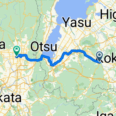
Route highlights
Points of interest along the route
Point of interest after 1.9 km
くすり学習館
Point of interest after 5.1 km
油日神社(日本遺産構成文化財)
Point of interest after 6.5 km
櫟野寺(日本遺産構成文化財)
Point of interest after 9.9 km
大鳥神社(日本遺産構成文化財)
Drinking water after 13 km
甲賀もちふる里館
Point of interest after 14.7 km
佐治城跡(日本遺産構成文化財)
Point of interest after 19.9 km
水口岡山城跡(日本遺産構成文化財)
Drinking water after 19.9 km
御菓子匠一味屋
Point of interest after 20 km
東海道水口宿大池町のからくり時計
Photo after 21.2 km
甲賀市役所
Drinking water after 21.5 km
駄菓子大津屋
Point of interest after 22.3 km
柏木神社(日本遺産構成文化財)
Photo after 32.1 km
甲賀流リアル忍者館
Continue with Bikemap
Use, edit, or download this cycling route
You would like to ride 甲賀コース(忍びの里サイクリングコース) or customize it for your own trip? Here is what you can do with this Bikemap route:
Free features
- Save this route as favorite or in collections
- Copy & plan your own version of this route
- Sync your route with Garmin or Wahoo
Premium features
Free trial for 3 days, or one-time payment. More about Bikemap Premium.
- Navigate this route on iOS & Android
- Export a GPX / KML file of this route
- Create your custom printout (try it for free)
- Download this route for offline navigation
Discover more Premium features.
Get Bikemap PremiumFrom our community
Other popular routes starting in Minakuchichō-matoba
 梅影町4-2, 湖南市 to 水口町水口5587-3, 甲賀市
- Distance
- 13.6 km
- Ascent
- 1,845 m
- Descent
- 1,829 m
- Location
- Minakuchichō-matoba, Shiga Prefecture, Japan
 to camp
- Distance
- 29 km
- Ascent
- 113 m
- Descent
- 203 m
- Location
- Minakuchichō-matoba, Shiga Prefecture, Japan
 国道307号, Koka to 1393, Murai, Hino, Gamo-Gun
- Distance
- 37.5 km
- Ascent
- 1,115 m
- Descent
- 1,097 m
- Location
- Minakuchichō-matoba, Shiga Prefecture, Japan
 Minakuchichō-matoba - Kyoto
- Distance
- 42.3 km
- Ascent
- 15 m
- Descent
- 310 m
- Location
- Minakuchichō-matoba, Shiga Prefecture, Japan
 旧東海道自転車の旅~Day 7
- Distance
- 57.3 km
- Ascent
- 173 m
- Descent
- 280 m
- Location
- Minakuchichō-matoba, Shiga Prefecture, Japan
 1018, Minakuchichomushono, Koka to 1-16, Shibukawa 1-Chōme, Kusatsu
- Distance
- 23.8 km
- Ascent
- 80 m
- Descent
- 154 m
- Location
- Minakuchichō-matoba, Shiga Prefecture, Japan
 信楽駅ーミホ・ミュージアム−草津
- Distance
- 30.8 km
- Ascent
- 307 m
- Descent
- 502 m
- Location
- Minakuchichō-matoba, Shiga Prefecture, Japan
 Kamitomoda, Iga to Midai, Iga
- Distance
- 10.2 km
- Ascent
- 116 m
- Descent
- 117 m
- Location
- Minakuchichō-matoba, Shiga Prefecture, Japan
Open it in the app