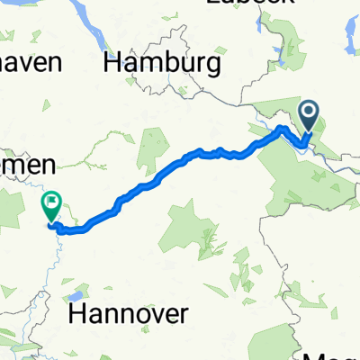
BiosphÀre erfahren mit River Hopping
A cycling route starting in LĂŒbtheen, Mecklenburg-Vorpommern, Germany.
Overview
About this route
A beautiful route through the Elbe River Landscape Biosphere Reserve with the option to travel directly by train from Hamburg (every two hours on weekends) and also return (Brahlstorf station). There is currently a pedestrian ferry planned from Boizenburg to Brackede, which would shorten the route by about 20 kilometers. For those who find the nearly 100 kilometers too long, it is possible to return directly to Brahlstorf after crossing from Bleckede. In Bleckede, a visit to the Biosphaerium Elbtalaue Schloss Bleckede with its observation tower is also worthwhile. Gastronomic facilities can be found in Preten (Cafe zum Schwarzen Schaf), Boizenburg, Lauenburg, Hohnstorf, Radegast, Heisterbusch, Bleckede, Stiepelse, Neu Garge, Darchau, Neuhaus.
- -:--
- Duration
- 91.1 km
- Distance
- 102 m
- Ascent
- 105 m
- Descent
- ---
- Avg. speed
- ---
- Max. altitude
Route quality
Waytypes & surfaces along the route
Waytypes
Track
23.7 km
(26 %)
Road
20.9 km
(23 %)
Surfaces
Paved
70.1 km
(77 %)
Unpaved
9.1 km
(10 %)
Asphalt
45.5 km
(50 %)
Concrete
19.1 km
(21 %)
Continue with Bikemap
Use, edit, or download this cycling route
You would like to ride BiosphÀre erfahren mit River Hopping or customize it for your own trip? Here is what you can do with this Bikemap route:
Free features
- Save this route as favorite or in collections
- Copy & plan your own version of this route
- Split it into stages to create a multi-day tour
- Sync your route with Garmin or Wahoo
Premium features
Free trial for 3 days, or one-time payment. More about Bikemap Premium.
- Navigate this route on iOS & Android
- Export a GPX / KML file of this route
- Create your custom printout (try it for free)
- Download this route for offline navigation
Discover more Premium features.
Get Bikemap PremiumFrom our community
Other popular routes starting in LĂŒbtheen
- Vielank-Zarrentin
- Distance
- 51.1 km
- Ascent
- 110 m
- Descent
- 87 m
- Location
- LĂŒbtheen, Mecklenburg-Vorpommern, Germany
- Vielank1
- Distance
- 22.3 km
- Ascent
- 42 m
- Descent
- 43 m
- Location
- LĂŒbtheen, Mecklenburg-Vorpommern, Germany
- LĂŒbtheen -> Pritzier -> Hagenow -> Warlitz -> LĂŒbtheen
- Distance
- 37.5 km
- Ascent
- 119 m
- Descent
- 122 m
- Location
- LĂŒbtheen, Mecklenburg-Vorpommern, Germany
- LĂŒbtheen -> GöĂlow -> Pritzier -> LĂŒbtheen
- Distance
- 23.6 km
- Ascent
- 89 m
- Descent
- 86 m
- Location
- LĂŒbtheen, Mecklenburg-Vorpommern, Germany
- TRV 2013 dag 2
- Distance
- 176.4 km
- Ascent
- 382 m
- Descent
- 378 m
- Location
- LĂŒbtheen, Mecklenburg-Vorpommern, Germany
- Zur Elbe
- Distance
- 41.5 km
- Ascent
- 51 m
- Descent
- 54 m
- Location
- LĂŒbtheen, Mecklenburg-Vorpommern, Germany
- Vielanker Brauhaus - Marschacht
- Distance
- 73.5 km
- Ascent
- 130 m
- Descent
- 135 m
- Location
- LĂŒbtheen, Mecklenburg-Vorpommern, Germany
- ATB_Vielank_03
- Distance
- 70.5 km
- Ascent
- 189 m
- Descent
- 151 m
- Location
- LĂŒbtheen, Mecklenburg-Vorpommern, Germany
Open it in the app