

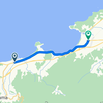
呼子~唐津市街サイクリング
A cycling route starting in Karatsu, Saga Prefecture, Japan.
Overview
About this route
- -:--
- Duration
- 22.2 km
- Distance
- 169 m
- Ascent
- 165 m
- Descent
- ---
- Avg. speed
- ---
- Max. altitude

Continue with Bikemap
Use, edit, or download this cycling route
You would like to ride 呼子~唐津市街サイクリング or customize it for your own trip? Here is what you can do with this Bikemap route:
Free features
- Save this route as favorite or in collections
- Copy & plan your own version of this route
- Sync your route with Garmin or Wahoo
Premium features
Free trial for 3 days, or one-time payment. More about Bikemap Premium.
- Navigate this route on iOS & Android
- Export a GPX / KML file of this route
- Create your custom printout (try it for free)
- Download this route for offline navigation
Discover more Premium features.
Get Bikemap PremiumFrom our community
Other popular routes starting in Karatsu
 呼子~唐津市街サイクリング
- Distance
- 22.2 km
- Ascent
- 169 m
- Descent
- 165 m
- Location
- Karatsu, Saga Prefecture, Japan
 呼子町呼子4185-12, 唐津市 to 二タ子2丁目2-46, 唐津市
- Distance
- 16.9 km
- Ascent
- 354 m
- Descent
- 370 m
- Location
- Karatsu, Saga Prefecture, Japan
 Hamasaki - Kyudai Ito
- Distance
- 32.3 km
- Ascent
- 200 m
- Descent
- 151 m
- Location
- Karatsu, Saga Prefecture, Japan
 Etapa 13: Karatsu - Fukuoka
- Distance
- 71.1 km
- Ascent
- 105 m
- Descent
- 205 m
- Location
- Karatsu, Saga Prefecture, Japan
 国道202号, Itoshima to 938-1, Nijofukae, Itoshima
- Distance
- 5.9 km
- Ascent
- 16 m
- Descent
- 20 m
- Location
- Karatsu, Saga Prefecture, Japan
 唐津~佐世保
- Distance
- 103.8 km
- Ascent
- 1,600 m
- Descent
- 1,597 m
- Location
- Karatsu, Saga Prefecture, Japan
 Karatsu-Nanayama-Kyuragi Loop
- Distance
- 72.7 km
- Ascent
- 890 m
- Descent
- 891 m
- Location
- Karatsu, Saga Prefecture, Japan
 海辺の絶景サイクリング
- Distance
- 11.8 km
- Ascent
- 65 m
- Descent
- 64 m
- Location
- Karatsu, Saga Prefecture, Japan
Open it in the app