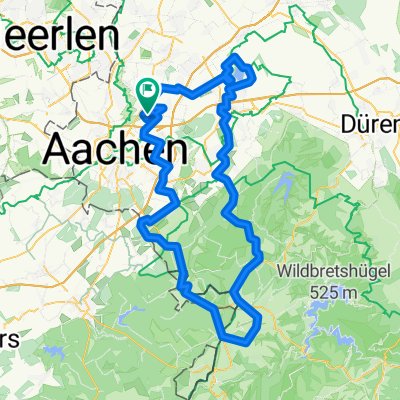
Tini-Tour
A cycling route starting in Würselen, North Rhine-Westphalia, Germany.
Overview
About this route
Würselen, Aachen, Vaals, Mechelen, Eys, Trintelen, Wijlre, Vaals, Aachen, Würselen
- -:--
- Duration
- 59.7 km
- Distance
- 451 m
- Ascent
- 464 m
- Descent
- ---
- Avg. speed
- 208 m
- Max. altitude
Route quality
Waytypes & surfaces along the route
Waytypes
Road
17.9 km
(30 %)
Cycleway
11.3 km
(19 %)
Surfaces
Paved
49 km
(82 %)
Asphalt
38.8 km
(65 %)
Concrete
10.1 km
(17 %)
Undefined
10.7 km
(18 %)
Continue with Bikemap
Use, edit, or download this cycling route
You would like to ride Tini-Tour or customize it for your own trip? Here is what you can do with this Bikemap route:
Free features
- Save this route as favorite or in collections
- Copy & plan your own version of this route
- Sync your route with Garmin or Wahoo
Premium features
Free trial for 3 days, or one-time payment. More about Bikemap Premium.
- Navigate this route on iOS & Android
- Export a GPX / KML file of this route
- Create your custom printout (try it for free)
- Download this route for offline navigation
Discover more Premium features.
Get Bikemap PremiumFrom our community
Other popular routes starting in Würselen
- Würselen - Pier - Würselen
- Distance
- 59.7 km
- Ascent
- 162 m
- Descent
- 170 m
- Location
- Würselen, North Rhine-Westphalia, Germany
- Von Würselen über Belgien und Holland und zurück Runde
- Distance
- 64.2 km
- Ascent
- 636 m
- Descent
- 663 m
- Location
- Würselen, North Rhine-Westphalia, Germany
- Aachener Süden AZ/AN 01
- Distance
- 36.3 km
- Ascent
- 292 m
- Descent
- 292 m
- Location
- Würselen, North Rhine-Westphalia, Germany
- Würselen - Köln
- Distance
- 84.7 km
- Ascent
- 145 m
- Descent
- 281 m
- Location
- Würselen, North Rhine-Westphalia, Germany
- Kleine Wurmrunde
- Distance
- 18.4 km
- Ascent
- 315 m
- Descent
- 315 m
- Location
- Würselen, North Rhine-Westphalia, Germany
- Bardenberger Straat - Wolff Aachen
- Distance
- 13 km
- Ascent
- 113 m
- Descent
- 110 m
- Location
- Würselen, North Rhine-Westphalia, Germany
- Kohlscheid-Landgraaf-Hzg-Alsdorf-Begau-Linden-Wuerselen-Bardenberg 2
- Distance
- 37 km
- Ascent
- 242 m
- Descent
- 242 m
- Location
- Würselen, North Rhine-Westphalia, Germany
- Eilendorf-Verlautenheide-Hochwald-Stolberg-Eilendorf
- Distance
- 16.2 km
- Ascent
- 127 m
- Descent
- 125 m
- Location
- Würselen, North Rhine-Westphalia, Germany
Open it in the app