
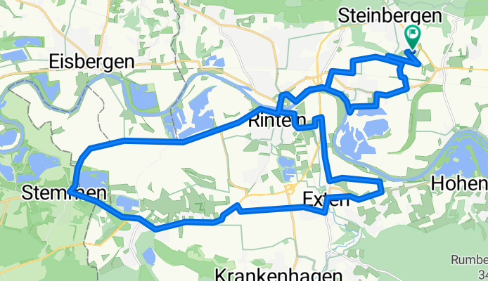
Kalletal
A cycling route starting in Buchholz, Lower Saxony, Germany.
Overview
About this route
- 2 h 5 min
- Duration
- 31.8 km
- Distance
- 55 m
- Ascent
- 55 m
- Descent
- 15.2 km/h
- Avg. speed
- ---
- Max. altitude

Route quality
Waytypes & surfaces along the route
Waytypes
Track
8.9 km
(28 %)
Quiet road
6.4 km
(20 %)
Surfaces
Paved
26.1 km
(82 %)
Unpaved
3.5 km
(11 %)
Asphalt
25.1 km
(79 %)
Unpaved (undefined)
2.5 km
(8 %)
Continue with Bikemap
Use, edit, or download this cycling route
You would like to ride Kalletal or customize it for your own trip? Here is what you can do with this Bikemap route:
Free features
- Save this route as favorite or in collections
- Copy & plan your own version of this route
- Sync your route with Garmin or Wahoo
Premium features
Free trial for 3 days, or one-time payment. More about Bikemap Premium.
- Navigate this route on iOS & Android
- Export a GPX / KML file of this route
- Create your custom printout (try it for free)
- Download this route for offline navigation
Discover more Premium features.
Get Bikemap PremiumFrom our community
Other popular routes starting in Buchholz
 Weser / Hohenstein / Schneegrund /Schaumburg
- Distance
- 43.6 km
- Ascent
- 697 m
- Descent
- 697 m
- Location
- Buchholz, Lower Saxony, Germany
 Fuhlen Feld Rinteln Wo
- Distance
- 35.5 km
- Ascent
- 291 m
- Descent
- 296 m
- Location
- Buchholz, Lower Saxony, Germany
 Hin-und Rückweg Arbeit
- Distance
- 34.3 km
- Ascent
- 390 m
- Descent
- 418 m
- Location
- Buchholz, Lower Saxony, Germany
 Rund um den Bückeberg
- Distance
- 37.1 km
- Ascent
- 294 m
- Descent
- 353 m
- Location
- Buchholz, Lower Saxony, Germany
 Kalletal
- Distance
- 31.8 km
- Ascent
- 55 m
- Descent
- 55 m
- Location
- Buchholz, Lower Saxony, Germany
 2014 - Schloß Arensburg - Bielefeld
- Distance
- 70.2 km
- Ascent
- 176 m
- Descent
- 180 m
- Location
- Buchholz, Lower Saxony, Germany
 Hävern bei Petershagen - Rolf Fähre
- Distance
- 29.1 km
- Ascent
- 76 m
- Descent
- 158 m
- Location
- Buchholz, Lower Saxony, Germany
 Grohnder Fährhaus und zurück
- Distance
- 76.6 km
- Ascent
- 578 m
- Descent
- 624 m
- Location
- Buchholz, Lower Saxony, Germany
Open it in the app