
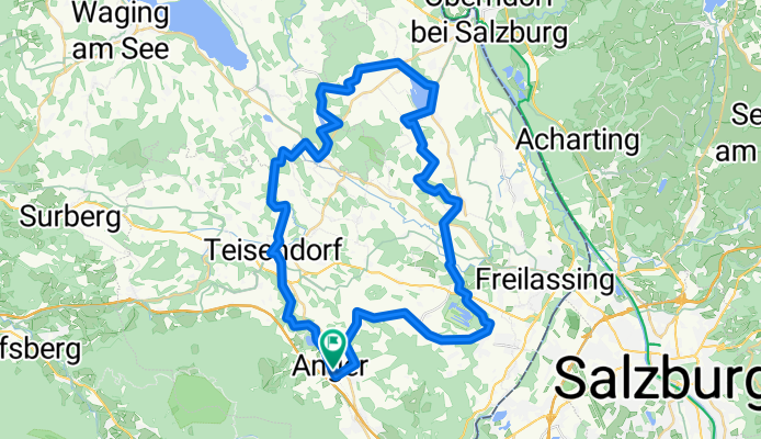
Moor und Moos-Radweg
A cycling route starting in Anger, Bavaria, Germany.
Overview
About this route
Die Moorlandschaften des nördlichen Landkreises mit dem Schönramer Filz als Highlight.
- -:--
- Duration
- 51.1 km
- Distance
- 710 m
- Ascent
- 709 m
- Descent
- ---
- Avg. speed
- ---
- Max. altitude
Route quality
Waytypes & surfaces along the route
Waytypes
Quiet road
22.5 km
(44 %)
Track
11.8 km
(23 %)
Surfaces
Paved
25.9 km
(51 %)
Unpaved
14 km
(27 %)
Asphalt
25.5 km
(50 %)
Gravel
12.3 km
(24 %)
Continue with Bikemap
Use, edit, or download this cycling route
You would like to ride Moor und Moos-Radweg or customize it for your own trip? Here is what you can do with this Bikemap route:
Free features
- Save this route as favorite or in collections
- Copy & plan your own version of this route
- Sync your route with Garmin or Wahoo
Premium features
Free trial for 3 days, or one-time payment. More about Bikemap Premium.
- Navigate this route on iOS & Android
- Export a GPX / KML file of this route
- Create your custom printout (try it for free)
- Download this route for offline navigation
Discover more Premium features.
Get Bikemap PremiumFrom our community
Other popular routes starting in Anger
 von Anger zur Stoißeralm
- Distance
- 14.1 km
- Ascent
- 1,122 m
- Descent
- 404 m
- Location
- Anger, Bavaria, Germany
 Burgkirchen 110 km
- Distance
- 107.4 km
- Ascent
- 451 m
- Descent
- 462 m
- Location
- Anger, Bavaria, Germany
 Rupertiwinkel
- Distance
- 55.1 km
- Ascent
- 210 m
- Descent
- 213 m
- Location
- Anger, Bavaria, Germany
 Stoisseralm mit Hari
- Distance
- 19.2 km
- Ascent
- 948 m
- Descent
- 854 m
- Location
- Anger, Bavaria, Germany
 FeWo - Fuschertörl
- Distance
- 104.6 km
- Ascent
- 2,370 m
- Descent
- 486 m
- Location
- Anger, Bavaria, Germany
 Rossfeldrunde
- Distance
- 107 km
- Ascent
- 1,436 m
- Descent
- 1,436 m
- Location
- Anger, Bavaria, Germany
 Frillensee-Teisenberg 34,20 km
- Distance
- 34.2 km
- Ascent
- 1,176 m
- Descent
- 1,176 m
- Location
- Anger, Bavaria, Germany
 Stoisseralm Adlgaß
- Distance
- 33.4 km
- Ascent
- 1,134 m
- Descent
- 1,136 m
- Location
- Anger, Bavaria, Germany
Open it in the app