

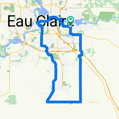
Chippewa River Trail north loop
A cycling route starting in Altoona, Wisconsin, United States.
Overview
About this route
- -:--
- Duration
- 33.7 km
- Distance
- 121 m
- Ascent
- 121 m
- Descent
- ---
- Avg. speed
- ---
- Max. altitude

Route quality
Waytypes & surfaces along the route
Waytypes
Cycleway
15.5 km
(46 %)
Quiet road
11.8 km
(35 %)
Surfaces
Paved
17.5 km
(52 %)
Asphalt
9.4 km
(28 %)
Paved (undefined)
5.7 km
(17 %)
Continue with Bikemap
Use, edit, or download this cycling route
You would like to ride Chippewa River Trail north loop or customize it for your own trip? Here is what you can do with this Bikemap route:
Free features
- Save this route as favorite or in collections
- Copy & plan your own version of this route
- Sync your route with Garmin or Wahoo
Premium features
Free trial for 3 days, or one-time payment. More about Bikemap Premium.
- Navigate this route on iOS & Android
- Export a GPX / KML file of this route
- Create your custom printout (try it for free)
- Download this route for offline navigation
Discover more Premium features.
Get Bikemap PremiumFrom our community
Other popular routes starting in Altoona
 Chippewa River Trail north loop
- Distance
- 33.7 km
- Ascent
- 121 m
- Descent
- 121 m
- Location
- Altoona, Wisconsin, United States
 Chippewa River Trail loop
- Distance
- 60.1 km
- Ascent
- 205 m
- Descent
- 205 m
- Location
- Altoona, Wisconsin, United States
 Lakeside route through the neighborhoods
- Distance
- 17.8 km
- Ascent
- 71 m
- Descent
- 73 m
- Location
- Altoona, Wisconsin, United States
 Fall Creek & Lake Altoona
- Distance
- 52 km
- Ascent
- 198 m
- Descent
- 197 m
- Location
- Altoona, Wisconsin, United States
 Old Abe trail loop
- Distance
- 138.3 km
- Ascent
- 233 m
- Descent
- 233 m
- Location
- Altoona, Wisconsin, United States
 Southern Eau Claire Loop
- Distance
- 48.7 km
- Ascent
- 159 m
- Descent
- 160 m
- Location
- Altoona, Wisconsin, United States
 Kingswood Court 3705, Eau Claire to Kingswood Court 3705, Eau Claire
- Distance
- 18.8 km
- Ascent
- 80 m
- Descent
- 80 m
- Location
- Altoona, Wisconsin, United States
 50 mile loop east side
- Distance
- 82.6 km
- Ascent
- 383 m
- Descent
- 383 m
- Location
- Altoona, Wisconsin, United States
Open it in the app