

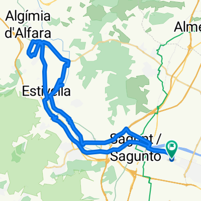
Sagunto circular por Alfara y Torres Torres
A cycling route starting in Sagunto, Valencia, Spain.
Overview
About this route
Statistics calculated from imported data
Wednesday, May 15, 2019 10:08 CEST Distance: 40.2 km Duration: 6 hours, 27 minutes and 1 second Average speed: 6.2 km/h Minimum elevation: 40 m Maximum elevation: 213 m Total ascent: 453 m Total descent: 472 m
- -:--
- Duration
- 40.3 km
- Distance
- 403 m
- Ascent
- 402 m
- Descent
- ---
- Avg. speed
- ---
- Max. altitude

Route quality
Waytypes & surfaces along the route
Waytypes
Quiet road
18.5 km
(46 %)
Track
12.9 km
(32 %)
Surfaces
Paved
20.2 km
(50 %)
Unpaved
4.4 km
(11 %)
Asphalt
13.3 km
(33 %)
Paved (undefined)
6.9 km
(17 %)
Continue with Bikemap
Use, edit, or download this cycling route
You would like to ride Sagunto circular por Alfara y Torres Torres or customize it for your own trip? Here is what you can do with this Bikemap route:
Free features
- Save this route as favorite or in collections
- Copy & plan your own version of this route
- Sync your route with Garmin or Wahoo
Premium features
Free trial for 3 days, or one-time payment. More about Bikemap Premium.
- Navigate this route on iOS & Android
- Export a GPX / KML file of this route
- Create your custom printout (try it for free)
- Download this route for offline navigation
Discover more Premium features.
Get Bikemap PremiumFrom our community
Other popular routes starting in Sagunto
 4 Sagunt Siete Aguas
- Distance
- 88.9 km
- Ascent
- 794 m
- Descent
- 112 m
- Location
- Sagunto, Valencia, Spain
 Sagunto circular por Alfara y Torres Torres
- Distance
- 40.3 km
- Ascent
- 403 m
- Descent
- 402 m
- Location
- Sagunto, Valencia, Spain
 Sagunto - Antenas Picayo - Pico Aguila - Mola - Xocainet - Gilet -Sagunto
- Distance
- 34.7 km
- Ascent
- 709 m
- Descent
- 709 m
- Location
- Sagunto, Valencia, Spain
 puerto sagunto-aqüeducte dels arcs-torres torres-puerto sagunto-
- Distance
- 38.2 km
- Ascent
- 313 m
- Descent
- 310 m
- Location
- Sagunto, Valencia, Spain
 Dag 2: Sagunto - Castello de la plana - 54 km
- Distance
- 53.7 km
- Ascent
- 1,612 m
- Descent
- 1,512 m
- Location
- Sagunto, Valencia, Spain
 dave77: Sagunto - Peñas de Guaita - Santo Espiritu - Gilet - Sagunto (variante x Rafa)
- Distance
- 18.2 km
- Ascent
- 347 m
- Descent
- 347 m
- Location
- Sagunto, Valencia, Spain
 La bergonzosa
- Distance
- 57.9 km
- Ascent
- 747 m
- Descent
- 747 m
- Location
- Sagunto, Valencia, Spain
 Fernando 12
- Distance
- 153.1 km
- Ascent
- 1,259 m
- Descent
- 1,259 m
- Location
- Sagunto, Valencia, Spain
Open it in the app